![]()
Satellite Photography
The National Archives Cartographic Branch holds satellite photography covering most of the world. This photography can be found in a few different series located in two Record Groups: 1. Satellite Imagery for the CORONA, ARGON, and LANYARD Program, 1959 - 1972, Keyhole-7 (KH-7) Satellite Photography, 7/1/1963 - 6/30/1967 and Keyhole-9 (KH-9) Satellite Imagery, 3/1/1973 - 10/31/1980 from Record Group 263: Records of the Central Intelligence Agency; and 2. Keyhole-9 (KH-9) Aerial Photographs, 6/1971 - 4/1986 from Record Group 537: Records of the National Geospatial-Intelligence Agency.
CORONA (KH-1, KH-2, KH-3, KH-4, KH-4A, KH-4B), ARGON (KH-5) and LANYARD (KH-6) Photography
CORONA, ARGON and LANYARD satellite photography can be located by accessing indexes in the Cartographic Research Room. In our research room, we have an index that lead to charts in RG 263: Photomosaic World Aeronautical Charts, 9/1960 - 6/1972 based on your area of interest.

RG 263, Satellite Imagery for the CORONA, ARGON, and LANYARD Program, 1959 - 1972, WAC Chart Index Map

Once you obtain access to these charts, you can see if coverage exists for your specific area. The images attached to the maps show which coverage is available. Once you locate coverage, the charts will provide you with mission information which will lead you to a can of aerial film in RG 263: Satellite Imagery for the CORONA, ARGON, and LANYARD Program, 1959 - 1972. Our can locators for satellite photography will provide film can numbers for each mission. You can search the can locators using the mission information from the indexes.
CORONA Film Cans

Using the information from the WAC chart, you can search the fields in the can locator to find the exact film cans that the photography is on. If missions include can numbers in the "SAT DP Number" field, this means there are duplicate cans that are available onsite. If there is only a CON can number listed, this means there are only original negatives and there are not duplicates onsite. In this case, the photographs are original negatives which are stored at the Lenexa Federal Records Center. These cans can be ordered in the Cartographic Research Room and arrive within three business days. If you already have a researcher card, you can order CON cans ahead of your visit to our site.
In this case, the photographs would be on film cans DP6663 and DP6732.
In some cases, the numbers for the Fwd and Aft photographs will not match up exactly and will have different exposure numbers. For example, for Mission 1007-1 (shown on the index), the area covered on Aft-118 is found on Fwd-113. Both of these numbers will be listed on the index (see above).

RG 263, Satellite Imagery for the CORONA, ARGON, and LANYARD Program, 1959 - 1972, Mission 1007-1, Pass 56-D, Aft-118 (available online via USGS EarthExplorer, Entity ID DS1007-1056DA118)

RG 263, Satellite Imagery for the CORONA, ARGON, and LANYARD Program, 1959 - 1972, Mission 1007-1, Pass 56-D, Fwd-113 (available online via USGS EarthExplorer, Entity ID DS1007-1056DF113)
KH-7 (GAMBIT) Photography
KH-7 photography, Keyhole-7 (KH-7) Satellite Photography, 7/1/1963 - 6/30/1967, can be searched by first using our WAC index map in the Cartographic research room.

Once you identify a WAC number that covers your area of interest, you can search that number in our KH-7 mission locator.

From here you can identify the mission number, pass and film can that holds the photography. You can now either access the film or use the index to view the flight line first.
The indexes are Mission Coverage Plots which consist of flight line indexes for any given mission.
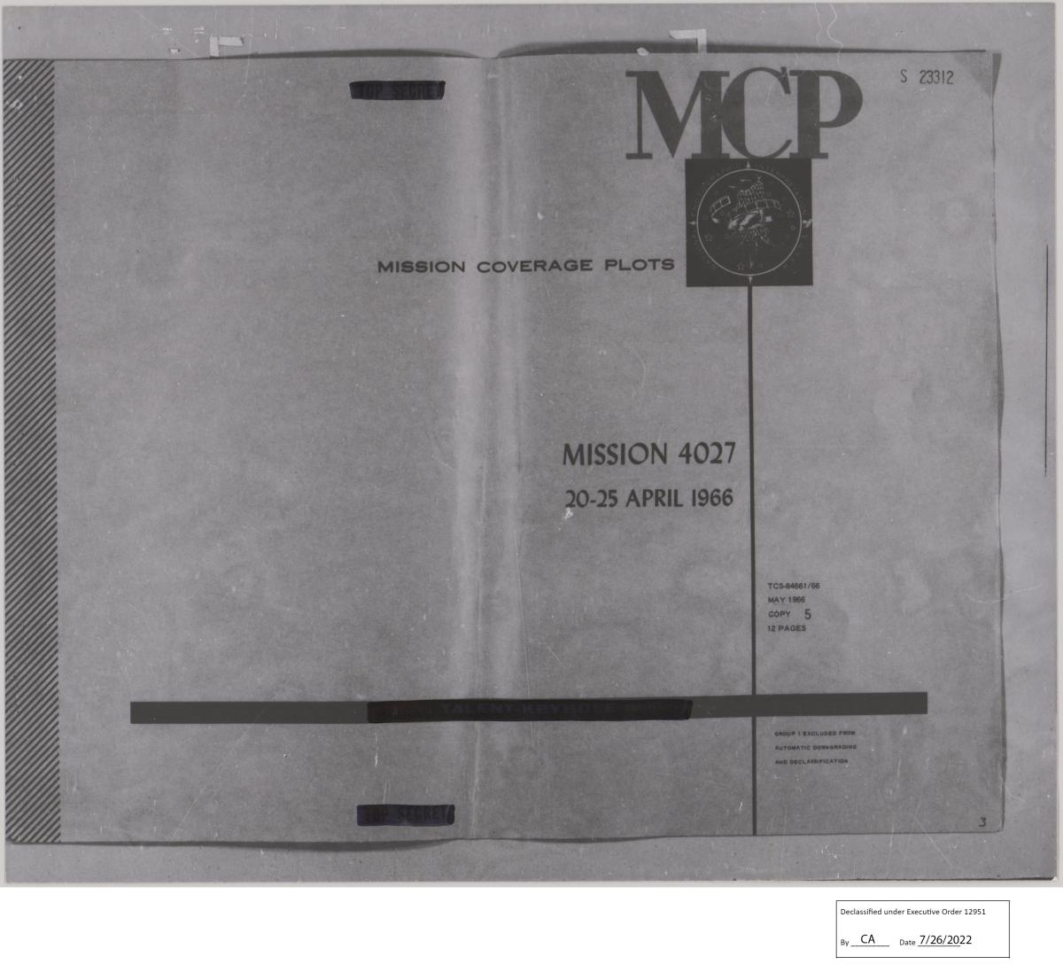
Cover page for the Mission Coverage Plot for Keyhole-7 (KH-7) Satellite Photography, 7/1/1963 - 6/30/1967, Mission 4027

Mission Coverage Plot index for Keyhole-7 (KH-7) Satellite Photography, 7/1/1963 - 6/30/1967, Mission 4027, Pass 75D
Using these indexes you can see the flight line and frame numbers for the mission and pass that you searched in the mission locator. Once you view the indexes, you can then request to view the film using the can number listed in the mission locator.

RG 263, Keyhole-7 (KH-7) Satellite Photography, 7/1/1963 - 6/30/1967, Mission 4027, Pass 75D, Frame 8 (available online via USGS EarthExplorer, Entity ID DZB00402700075H008001)
KH-9 (HEXAGON) Photography
Images in RG 537: Keyhole-9 (KH-9) Aerial Photographs, 6/1971 - 4/1986 and RG 263: Keyhole-9 (KH-9) Satellite Imagery, 3/1/1973 - 10/31/1980 can be searched by first using our ONC index map in the Cartographic research room.
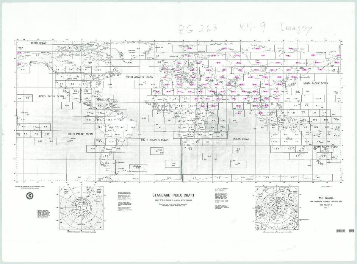
RG 263: Keyhole-9 (KH-9) Satellite Imagery, 3/1/1973 - 10/31/1980 and RG 537: Keyhole-9 (KH-9) Aerial Photographs, 6/1971 - 4/1986, ONC Chart Index Map
Once you identify an ONC number that covers your area of interest, you can search the corresponding mosaic index for that area.
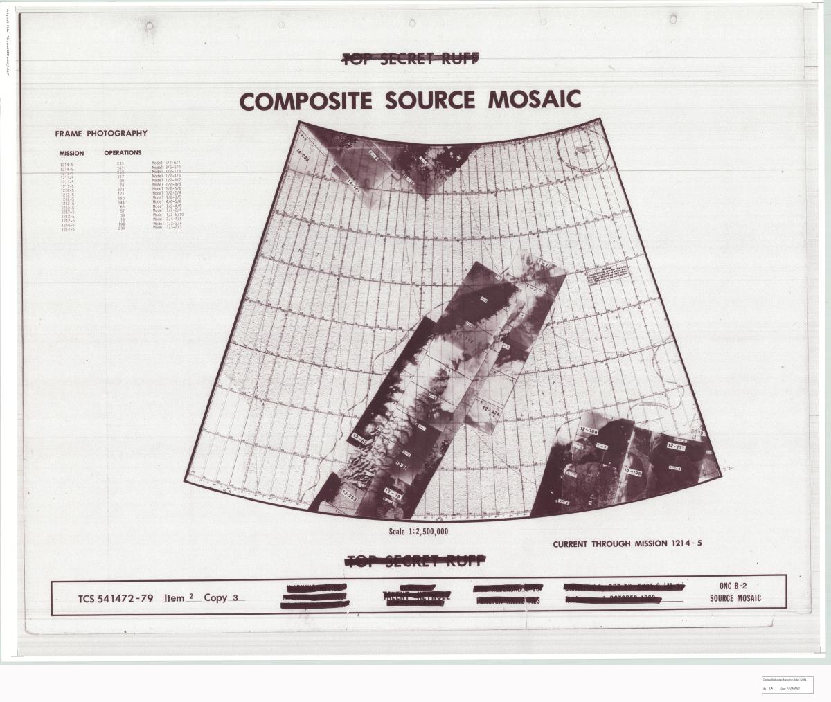
Once you obtain access to these charts, you can see if coverage exists for your specific area. The images on the indexes show which coverage is available. Once you locate coverage, the indexes will provide you with mission information which will lead you to a can of aerial film in either RG 263: Keyhole-9 (KH-9) Satellite Imagery, 3/1/1973 - 10/31/1980 and RG 537: Keyhole-9 (KH-9) Aerial Photographs, 6/1971 - 4/1986. Our can locators for KH-9 satellite photography will provide film can numbers for each mission. You can search the can locators using the mission information from the indexes.
Additionally, we have spreadsheets which provide information for various KH-9 missions. These spreadsheets include the geographic coordinates for each KH-9 frame, so they can be searched by location. Although these finding aids are complicated, please do no hesitate to email us to ask for assistance at carto@nara.gov.
The finding aids can be used by searching for your geographic coordinates.

Once you locate the general area of your coordinates in the spreadsheets, the associated mission information will be listed under the “Mission,” “Bucket” and “OP” fields. You can then search the KH-9 can locator to find the available film cans that hold these images using the information from the spreadsheets or the mosaic indexes.


The ON or CON number represents the original film can. If there is a SAT DP can number, you can order that in our research room and view onsite. If there is only an ON or CON number, you would need to order the can to be delivered from our Lenexa Federal Records Center. These cans may be ordered in the Cartographic Research Room and arrive there within three business days. If you already have a researcher card, you can order ON cans ahead of your visit to our site. Some ON cans for this record group are onsite and these are noted in the can locator.
Once you order the cans, you can view and copy them in the Cartographic Research Room. We have light tables which allow you to view the film and take photographs on a personal camera. We also have aerial film scanners available. If you have a USB capable laptop, you can bring it to our research room and scan the photographs to your computer. The full images cannot be scanned on these scanners due to the size of the photographs, but separate images can be stitched together to create the full image. You can learn more about aerial photography reproductions here.

RG 263, KH-9 Satellite Photography, Mission 1208-5, Pass 176, Frame 5 (available online via USGS EarthExplorer, Entity ID DZB1208-500176L001001)
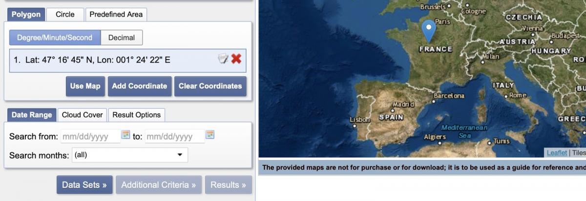
While satellite imagery can be difficult to scan due to the size of the photographs on the reels, many of the photographs are already digitized and can be accessed using the USGS EarthExplorer. Directions for using the site are as follows:
1. Search Criteria: Set your Search Criteria using the options given. You can add geographic coordinates to view all aerial coverage for your specific area. You can also add dates to search for a specific time frame.

Geographic coordinates can be added by clicking "Add Coordinate" or you can click on a location on the map and the coordinates will automatically be added.
2. Data Sets: To search satellite imagery, select Declassified Data, then select one or more of the available data sets:

Declass 1 (1996): For CORONA, ARGON, and LANYARD (1960-1972)
Declass 2 (2002): For KH-7 (1963-1967) and KH-9 (1973-1980)
Declass 3 (2013): For KH-9 (1971-1984)
3. Additional Criteria: Choose or enter information for any of the fields in order to refine your search. Or leave as is to widen your search results.

If available, based on which type of images you are searching for, you can include the pass number (which is part of the mission information found on our indexes) as a five digit number in the “Operations Number” field (ex: Pass 1 - Operations Number 00001; Pass 176 - Operations Number 00176). This can help you narrow down specific images that are part of a larger mission. The pass number may be found in the can locators or on the WAC charts used as indexes.
4. Click Results. You may use the Show Results Controls options to view the aerial coverage for each photo on the map. Each image should also have its own toolbar set of options for display and download. Hover the mouse over the icons in the results toolbars for each image for a brief title of each option.


If you have any questions regarding satellite photography, you can email the Cartographic Branch at carto@nara.gov.