![]()
Post Office Reports of Site Locations, 1837–1950
The National Archives Building in Washington, DC, houses surviving report forms sent to postmasters seeking information for the Topographer's Office to use in compiling postal route maps.
These records have been reproduced as Microfilm M1126, Post Office Department Records of Site Locations, 1837–1955 (683 rolls). M1126 has been digitized and made available online through the National Archives Catalog (National Archives Identifier 608210).
Historical Background
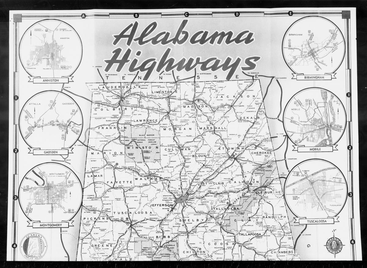
1942 Map of Alabama Highways
Included among the Post Office reports of site locations for Alabama (NAID 68174777)
Before 1837, the U.S. Post Office Department had no official mapmaker and purchased its maps from commercial firms or private individuals. On March 13, 1837, Henry A. Burr was appointed the first Topographer of the Post Office, and he began preparing maps for postal officials' use.
The reports of site locations provided data that the Topographer used in preparing these maps. They were also an important part of the process for establishing a new post office and for reporting changes in a post office's name or location.
The Appointment Division of the First Assistant Postmaster General's Office usually sent a site location report form to the postmaster nearest to a proposed post office. The postmaster would complete and return the form, and the Topographer would then use the information to determine the location of the proposed post office in relation to other nearby post offices, transportation routes, and facilities.
In 1862, Postmaster General Montgomery Blair directed the Topographer to prepare a comprehensive set of postal maps for sale to the public. Maps of states, or groups of states, were to be continually updated by the Topographer's Office. Later, similar maps were prepared for territories and possessions.
On January 3, 1955, the Postmaster General ordered the end of sales of postal route maps and eliminated the need to accumulate reports on postal office site locations.
More information regarding the Topographer and postal route maps may be found in Records and Policies of the Post Office Department Relating to Place-Names (National Archives Reference Information Paper No. 72).
Contents of Site Reports
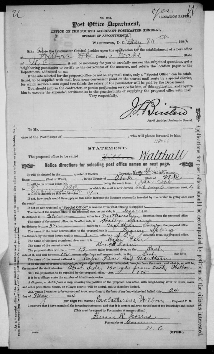
Although Post Office site location reports changed in format over the years, most requested the following information about a post office:
- County and State (or Territory);
- Land description used by the Federal survey system (range, township, and section), if applicable;
- Mail route number and distance to the nearest mail route; and
-
Closest rivers, creeks, canals, roads, and railroads.
The reports do not typically provide the exact locations of post offices (except for some in the 1940s, which provide street addresses), nor do they include information about the buildings in which post offices were housed or operated.
However, most reports include a diagram or sketch map compiled by the postmaster or a printed map that the postmaster annotated to show the approximate location of the post office.
Some reports also provide the name of the contractor for the mail route and the number of families or people who would be served by the post office.
Note that petitions were submitted with site location applications to request a new post office. However, while we have the original site location reports, the U.S. Postal Service did not keep the petitions. As such, these petitions no longer exist.
Arrangement of Site Reports
The Post Office site location reports are arranged alphabetically by state (including the District of Colombia). Reports for states are followed by reports for territories (Panama Canal Zone, Guam, Samoa, the Virgin Islands, Puerto Rico, and the Philippine Islands).
The reports for each state or territory are then arranged alphabetically by major civil division (county, parish, or district) and thereunder by the name of the post office in rough alphabetical order.
Multiple Reports
More than one report can exist for the same post office if the post office moved or its name changed. For post offices that moved, the reports are usually arranged chronologically with the most recent report first and the oldest report last. Reports for post offices whose names changed are normally filed under the most recent name, but sometimes they are filed under the earlier name(s).
Boundaries of civil divisions sometimes changed, so reports for a given post office might be filed under more than one county or state. Secondary sources such as gazetteers, atlases, and commercially published postal guides can be consulted to learn the name of the county in which a particular post office was located. These resources may be found at most large public libraries.
Site Reports by State/Territory
- Roll 1: Alabama, Autauga – Blount Counties
- Roll 2: Alabama, Bullock – Chilton Counties
- Roll 3: Alabama, Choctaw – Cleburne Counties
- Roll 4: Alabama, Coffee – Crenshaw Counties
- Roll 5: Alabama, Cullman – De Kalb Counties
- Roll 6: Alabama, Elmore – Fayette Counties
- Roll 7: Alabama, Franklin – Houston Counties
- Roll 8: Alabama, Jackson – Jefferson Counties
- Roll 9: Alabama, Lamar – Macon Counties
- Roll 10: Alabama, Madison – Marshall Counties
- Roll 11: Alabama, Mobile – Montgomery Counties
- Roll 12: Alabama, Morgan – Russell Counties
- Roll 13: Alabama, St. Clair – Tallapoosa Counties
- Roll 14: Alabama, Tuscaloosa – Washington Counties
- Roll 15: Alabama, Wilcox – Winston Counties
- Roll 16: Alaska, First Judicial District – Second Judicial District
- Roll 17: Alaska, Third Judicial District – Fourth Judicial District
- Roll 18: Arizona, Apache – Coconino Counties
- Roll 19: Arizona, Gila – Maricopa Counties
- Roll 20: Arizona, Mohave – Pima Counties
- Roll 21: Arizona, Pinal – Yuma Counties
- Roll 22: Arkansas, Arkansas – Ashley Counties
- Roll 23: Arkansas, Baxter – Benton Counties
- Roll 24: Arkansas, Boone – Carroll Counties
- Roll 25: Arkansas, Chicot – Cleburne Counties
- Roll 26: Arkansas, Cleveland – Craighead Counties
- Roll 27: Arkansas, Crawford – Cross Counties
- Roll 28: Arkansas, Dallas – Drew Counties
- Roll 29: Arkansas, Faulkner – Fulton Counties
- Roll 30: Arkansas, Garland – Greene Counties
- Roll 31: Arkansas, Hempstead – Howard Counties
- Roll 32: Arkansas, Independence – Izard Counties
- Roll 33: Arkansas, Jackson – Jefferson Counties
- Roll 34: Arkansas, Johnson – Lawrence Counties
- Roll 35: Arkansas, Lee – Little River Counties
- Roll 36: Arkansas, Logan – Lonoke Counties
- Roll 37: Arkansas, Madison – Marion Counties
- Roll 38: Arkansas, Miller – Monroe Counties
- Roll 39: Arkansas, Montgomery – Newton Counties
- Roll 40: Arkansas, Ouachita – Pike Counties
- Roll 41: Arkansas, Poinsett – Prairie Counties
- Roll 42: Arkansas, Pulaski – Randolph Counties
- Roll 43: Arkansas, St. Francis – Scott Counties
- Roll 44: Arkansas, Searcy – Sevier Counties
- Roll 45: Arkansas, Sharp – Union Counties
- Roll 46: Arkansas, Van Buren – Washington Counties
- Roll 47: Arkansas, White – Yell Counties
- Roll 48: California, Alameda – Butte Counties
- Roll 49: California, Calaveras – Contra Costa Counties
- Roll 50: California, Del Norte – Fresno Counties
- Roll 51: California, Glenn – Imperial Counties
- Roll 52: California, Inyo – Kern Counties
- Roll 53: California, Kings – Lassen Counties
- Roll 54: California, Los Angeles, A–L
- Roll 55: California, Los Angeles, M–Z
- Roll 56: California, Madera – Mariposa Counties
- Roll 57: California, Mendocino – Modoc Counties
- Roll 58: California, Mono – Nevada Counties
- Roll 59: California, Orange – Placer Counties
- Roll 60: California, Plumas – Riverside Counties
- Roll 61: California, Sacramento – San Benito Counties
- Roll 62: California, San Bernardino County
- Roll 63: California, San Diego County
- Roll 64: California, San Francisco – San Luis Obispo Counties
- Roll 65: California, San Mateo – Santa Clara Counties
- Roll 66: California, Santa Cruz – Sierra Counties
- Roll 67: California, Siskiyou – Sonoma Counties
- Roll 68: California, Stanislaus – Trinity Counties
- Roll 69: California, Tulare – Ventura Counties
- Roll 70: California, Yolo – Yuba Counties
- Roll 71: Colorado, Adams – Bent Counties
- Roll 72: Colorado, Boulder – Conejos Counties
- Roll 73: Colorado, Costilla – Douglas Counties
- Roll 74: Colorado, Eagle – Fremont Counties
- Roll 75: Colorado, Garfield – Hinsdale Counties
- Roll 76: Colorado, Huerfano – Lake Counties
- Roll 77: Colorado, La Plata – Las Animas Counties
- Roll 78: Colorado, Lincoln – Moffat Counties
- Roll 79: Colorado, Montezuma – Prowers Counties
- Roll 80: Colorado, Pueblo – Sedgwick Counties
- Roll 81: Colorado, Summit – Yuma Counties
- Roll 82: Connecticut, Fairfield – Hartford Counties
- Roll 83: Connecticut, Litchfield – Middlesex Counties
- Roll 84: Connecticut, New Haven – New London Counties
- Roll 85: Connecticut, Tolland – Windham Counties
Delaware; District of Columbia
- Roll 87: Florida, Alachua – Bay Counties
- Roll 88: Florida, Bradford – Calhoun Counties
- Roll 89: Florida, Charlotte – Dade Counties
- Roll 90: Florida, De Soto – Escambia Counties
- Roll 91: Florida, Flagler – Hernando Counties
- Roll 92: Florida, Highlands – Jackson Counties
- Roll 93: Florida, Jefferson – Madison Counties
- Roll 94: Florida, Manatee – Monroe Counties
- Roll 95: Florida, Nassau – Osceola Counties
- Roll 96: Florida, Palm Beach – Pinellas Counties
- Roll 97: Florida, Polk – Putnam Counties
- Roll 98: Florida, St. Johns – Suwannee Counties
- Roll 99: Florida, Taylor – Washington Counties
- Roll 100: Georgia, Appling – Bartow Counties
- Roll 101: Georgia, Ben Hill – Brantley Counties
- Roll 102: Georgia, Brooks – Camden Counties
- Roll 103: Georgia, Candler – Chattooga Counties
- Roll 104: Georgia, Cherokee – Cobb Counties
- Roll 105: Georgia, Coffee – Crawford Counties
- Roll 106: Georgia, Crisp – De Kalb Counties
- Roll 107: Georgia, Dodge – Early Counties
- Roll 108: Georgia, EchoIs – Emanuel Counties
- Roll 109: Georgia, Evans – Floyd Counties
- Roll 110: Georgia, Forsyth – Gilmer Counties
- Roll 111: Georgia, Glascock – Gwinnett Counties
- Roll 112: Georgia, Habersham – Hart Counties
- Roll 113: Georgia, Heard – Jenkins Counties
- Roll 114: Georgia, Johnson – Lincoln Counties
- Roll 115: Georgia, Long – Mclntosh Counties
- Roll 116: Georgia, Macon – Monroe Counties
- Roll 117: Georgia, Montgomery – Newton Counties
- Roll 118: Georgia, Oconee – Pickens Counties
- Roll 119: Georgia, Pierce – Schley Counties
- Roll 120: Georgia, Screven – Sumter Counties
- Roll 121: Georgia, Talbot – Terrell Counties
- Roll 122: Georgia, Thomas – Union Counties
- Roll 123: Georgia, Upson – Webster Counties
- Roll 124: Georgia, Wheeler – Worth Counties
- Roll 125: Hawaii, Hawaii – Maui Counties
- Roll 126: Idaho, Ada – Benewah Counties
- Roll 127: Idaho, Bingham – Bonneville Counties
- Roll 128: Idaho, Boundary – Custer Counties
- Roll 129: Idaho, Elmore – Gooding Counties
- Roll 130: Idaho, Idaho – Latah Counties
- Roll 131: Idaho, Lemhi – Oneida Counties
- Roll 132: Idaho, Owyhee – Shoshone Counties
- Roll 133: Idaho, Teton – Washington Counties
- Roll 134: Illinois, Adams – Brown Counties
- Roll 135: Illinois, Bureau – Cass Counties
- Roll 136: Illinois, Champaign – Coles Counties
- Roll 137: Illinois, Cook County, A–L
- Roll 138: Illinois, Cook County, M–Z
- Roll 139: Illinois, Crawford – Douglas Counties
- Roll 140: Illinois, Du Page – Effingham Counties
- Roll 141: Illinois, Fayette – Fulton Counties
- Roll 142: Illinois, Gallatin – Hancock Counties
- Roll 143: Illinois, Hardin – Jackson Counties
- Roll 144: Illinois, Jasper – Johnson Counties
- Roll 145: Illinois, Kane – Knox Counties
- Roll 146: Illinois, Lake – Lee Counties
- Roll 147: Illinois, Livingston – McLean Counties
- Roll 148: Illinois, Macon – Marion Counties
- Roll 149: Illinois, Marshall – Mercer Counties
- Roll 150: Illinois, Monroe – Moultrie Counties
- Roll 151: Illinois, Ogle – Piatt Counties
- Roll 152: Illinois, Pike – Putnam Counties
- Roll 153: Illinois, Randolph – Saline Counties
- Roll 154: Illinois, Sangamon – Stephenson Counties
- Roll 155: Illinois, Tazewell – Wabash Counties
- Roll 156: Illinois, Warren – Whiteside Counties
- Roll 157: Illinois, Will – Woodford Counties
- Roll 158: Indiana, Adams – Cass Counties
- Roll 159: Indiana, Clark – Decatur Counties
- Roll 160: Indiana, De Kalb – Fountain Counties
- Roll 161: Indiana, Franklin – Hamilton Counties
- Roll 162: Indiana, Hancock – Jasper Counties
- Roll 163: Indiana, Jay – Knox Counties
- Roll 164: Indiana, Kosciusko – Lawrence Counties
- Roll 165: Indiana, Madison – Monroe Counties
- Roll 166: Indiana, Montgomery – Orange Counties
- Roll 167: Indiana, Owen – Posey Counties
- Roll 168: Indiana, Pulaski – St. Joseph Counties
- Roll 169: Indiana, Scott – Switzerland Counties
- Roll 170: Indiana, Tippecanoe – Wabash Counties
- Roll 171: Indiana, Warren – Whitley Counties
- Roll 172: Iowa, Adair – Audubon Counties
- Roll 173: Iowa, Benton – Buchanan Counties
- Roll 174: Iowa, Buena Vista – Cerro Gordo Counties
- Roll 175: Iowa, Cherokee – Crawford Counties
- Roll 176: Iowa, Dallas – Delaware Counties
- Roll 177: Iowa, Des Moines – Floyd Counties
- Roll 178: Iowa, Franklin – Hancock Counties
- Roll 179: Iowa, Hardin – Iowa Counties
- Roll 180: Iowa, Jackson – Kossuth Counties
- Roll 181: Iowa, Lee – Mahaska Counties
- Roll 182: Iowa, Marion – Monona Counties
- Roll 183: Iowa, Monroe – Palo Alto Counties
- Roll 184: Iowa, Plymouth – Ringgold Counties
- Roll 185: Iowa, Sac – Story Counties
- Roll 186: Iowa, Tama – Washington Counties
- Roll 187: Iowa, Wayne – Wright Counties
- Roll 188: Kansas, Allen – Barber Counties
- Roll 189: Kansas, Barton – Chase Counties
- Roll 190: Kansas, Chautauqua – Clay Counties
- Roll 191: Kansas, Cloud – Crawford Counties
- Roll 192: Kansas, Decatur – Edwards Counties
- Roll 193: Kansas, Elk – Geary Counties
- Roll 194: Kansas, Gove – Harvey Counties
- Roll 195: Kansas, Haskell – Jewell Counties
- Roll 196: Kansas, Johnson – Leavenworth Counties
- Roll 197: Kansas, Lincoln – Lyon Counties
- Roll 198: Kansas, McPherson – Mitchell Counties
- Roll 199: Kansas, Montgomery – Ness Counties
- Roll 200: Kansas, Norton – Pawnee Counties
- Roll 201: Kansas, Phillips – Reno Counties
- Roll 202: Kansas, Republic – Russell Counties
- Roll 203: Kansas, Saline – Sherman Counties
- Roll 204: Kansas, Smith – Trego Counties
- Roll 205: Kansas, Wabaunsee – Wyandotte Counties
- Roll 206: Kentucky, Adair – Barren Counties
- Roll 207: Kentucky, Bath – Bell Counties
- Roll 208: Kentucky, Boone – Breathitt Counties
- Roll 209: Kentucky, Breckinridge – Butler Counties
- Roll 210: Kentucky, Caldwell – Carter Counties
- Roll 211: Kentucky, Casey – Clay Counties
- Roll 212: Kentucky, Clinton – Cumberland Counties
- Roll 213: Kentucky, Daviess – Estill Counties
- Roll 214: Kentucky, Fayette – Gallatin Counties
- Roll 215: Kentucky, Garrard – Green Counties
- Roll 216: Kentucky, Greenup – Hardin Counties
- Roll 217: Kentucky, Harlan – Hart Counties
- Roll 218: Kentucky, Henderson – Jackson Counties
- Roll 219: Kentucky, Jefferson – Kenton Counties
- Roll 220: Kentucky, Knott – Larue Counties
- Roll 221: Kentucky, Laurel – Lawrence Counties
- Roll 222: Kentucky, Lee – Letcher Counties
- Roll 223: Kentucky, Lewis – Logan Counties
- Roll 224: Kentucky, Lyon – Madison Counties
- Roll 225: Kentucky, Magoffin – Marshall Counties
- Roll 226: Kentucky, Martin – Mercer Counties
- Roll 227: Kentucky, Metcalfe – Morgan Counties
- Roll 228: Kentucky, Muhlenberg – Oldham Counties
- Roll 229: Kentucky, Owen – Perry Counties
- Roll 230: Kentucky, Pike County
- Roll 231: Kentucky, Powell – Pulaski Counties
- Roll 232: Kentucky, Robertson – Russell Counties
- Roll 233: Kentucky, Scott – Trigg Counties
- Roll 234: Kentucky, Trimble – Wayne Counties
- Roll 235: Kentucky, Webster – Woodford Counties
- Roll 236: Louisiana, Acadia – Assumption Parishes
- Roll 237: Louisiana, Avoyelles – Bienville Parishes
- Roll 238: Louisiana, Bossier – Caddo Parishes
- Roll 239: Louisiana, Calcasieu – Catahoula Parishes
- Roll 240: Louisiana, Claiborne – East Baton Rouge Parishes
- Roll 241: Louisiana, East Carroll – Grant Parishes
- Roll 242: Louisiana, Iberia – Lafourche Parishes
- Roll 243: Louisiana, La Salle – Morehouse Parishes
- Roll 244: Louisiana, Natchitoches – Ouachita Parishes
- Roll 245: Louisiana, Plaquemines – Pointe Coupee Parishes
- Roll 246: Louisiana, Rapides – Sabine Parishes
- Roll 247: Louisiana, St. Bernard – St. John the Baptist Parishes
- Roll 248: Louisiana, St. Landry – St. Tammany Parishes
- Roll 249: Louisiana, Tangipahoa – Union Parishes
- Roll 250: Louisiana, Vermilion – Washington Parishes
- Roll 251: Louisiana, Webster – Winn Parishes
- Roll 252: Maine, Androscoggin County
- Roll 253: Maine, Aroostook County
- Roll 254: Maine, Cumberland County
- Roll 255: Maine, Franklin – Hancock Counties
- Roll 256: Maine, Kennebec Counties
- Roll 257: Maine, Knox County
- Roll 258: Maine, Lincoln County
- Roll 259: Maine, Oxford County
- Roll 260: Maine, Penobscot County
- Roll 261: Maine, Piscataquis – Somerset Counties
- Roll 262: Maine, Waldo – Washington Counties
- Roll 263: Maine, York County
- Roll 264: Maryland, Allegany – Anne Arundel Counties
- Roll 265: Maryland, Baltimore County – Baltimore City
- Roll 266: Maryland, Calvert – Cecil Counties
- Roll 267: Maryland, Charles – Dorchester Counties
- Roll 268: Maryland, Frederick – Kent Counties
- Roll 269: Maryland, Montgomery – St. Mary's Counties
- Roll 270: Maryland, Somerset – Worcester Counties
- Roll 271: Massachusetts, Barnstable – Berkshire Counties
- Roll 272: Massachusetts, Bristol – Essex Counties
- Roll 273: Massachusetts, Franklin – Hampshire Counties
- Roll 274: Massachusetts, Middlesex – Norfolk Counties
- Roll 275: Massachusetts, Plymouth – Worcester Counties
- Roll 276: Michigan, Alcona – Barry Counties
- Roll 277: Michigan, Bay – Calhoun Counties
- Roll 278: Michigan, Cass – Clinton Counties
- Roll 279: Michigan, Crawford – Gladwin Counties
- Roll 280: Michigan, Gogebic – Huron Counties
- Roll 281: Michigan, Ingham – Isabella Counties
- Roll 282: Michigan, Jackson – Lake Counties
- Roll 283: Michigan, Lapeer – Macomb Counties
- Roll 284: Michigan, Manistee – Menominee Counties
- Roll 285: Michigan, Midland – Monroe Counties
- Roll 286: Michigan, Montcalm – Ogemaw Counties
- Roll 287: Michigan, Ontonagon – Roscommon Counties
- Roll 288: Michigan, Saginaw – Schoolcraft Counties
- Roll 289: Michigan, Shiawassee – Washtenaw Counties
- Roll 290: Michigan, Wayne – Wexford Counties
- Roll 291: Minnesota, Aitkin – Brown Counties
- Roll 292: Minnesota, Carlton – Cottonwood Counties
- Roll 293: Minnesota, Crow Wing – Goodhue Counties
- Roll 294: Minnesota, Grant – Hubbard Counties
- Roll 295: Minnesota, Isanti – Koochiching Counties
- Roll 296: Minnesota, Lac qui Parle – Meeker Counties
- Roll 297: Minnesota, Mille Lacs – Pennington Counties
- Roll 298: Minnesota, Pine – Rice Counties
- Roll 299: Minnesota, Rock – Stearns Counties
- Roll 300: Minnesota, Steele – Yellow Medicine Counties
- Roll 301: Mississippi, Adams – Attala Counties
- Roll 302: Mississippi, Benton – Bolivar Counties
- Roll 303: Mississippi, Calhoun – Choctaw Counties
- Roll 304: Mississippi, Claiborne – Coahoma Counties
- Roll 305: Mississippi, Copiah – Franklin Counties
- Roll 306: Mississippi, George – Harrison Counties
- Roll 307: Mississippi, Hinds – Issaquena Counties
- Roll 308: Mississippi, Itawamba – Jefferson Counties
- Roll 309: Mississippi, Jefferson Davis – Lafayette Counties
- Roll 310: Mississippi, Lamar – Lawrence Counties
- Roll 311: Mississippi, Leake – Lincoln Counties
- Roll 312: Mississippi, Lowndes – Monroe Counties
- Roll 313: Mississippi, Montgomery – Noxubee Counties
- Roll 314: Mississippi, Oktibbeha – Perry Counties
- Roll 315: Mississippi, Pike – Quitman Counties
- Roll 316: Mississippi, Rankin – Sharkey Counties
- Roll 317: Mississippi, Simpson – Sunflower Counties
- Roll 318: Mississippi, Tallahatchie – Tunica Counties
- Roll 319: Mississippi, Union – Wayne Counties
- Roll 320: Mississippi, Webster – Yazoo Counties
- Roll 321: Missouri, Adair – Audrain Counties
- Roll 322: Missouri, Barry – Benton Counties
- Roll 323: Missouri, Bollinger – Butler Counties
- Roll 324: Missouri, Caldwell – Camden Counties
- Roll 325: Missouri, Cape Girardeau – Cedar Counties
- Roll 326: Missouri, Chariton – Clay Counties
- Roll 327: Missouri, Clinton – Dade Counties
- Roll 328: Missouri, Dallas – Douglas Counties
- Roll 329: Missouri, Dunklin – Franklin Counties
- Roll 330: Missouri, Gasconade – Harrison Counties
- Roll 331: Missouri, Henry – Howell Counties
- Roll 332: Missouri, Iron – Jasper Counties
- Roll 333: Missouri, Jefferson – Knox Counties
- Roll 334: Missouri, Laclede – Lewis Counties
- Roll 335: Missouri, Lincoln – Macon Counties
- Roll 336: Missouri, Madison – Mississippi Counties
- Roll 337: Missouri, Moniteau – New Madrid Counties
- Roll 338: Missouri, Newton – Osage Counties
- Roll 339: Missouri, Ozark – Perry Counties
- Roll 340: Missouri, Pettis – Pike Counties
- Roll 341: Missouri, Platte – Putnam Counties
- Roll 342: Missouri, Ralls – Reynolds Counties
- Roll 343: Missouri, Ripley – St. Clair Counties
- Roll 344: Missouri, St. Francois – St. Louis Counties
- Roll 345: Missouri, Saline – Shelby Counties
- Roll 346: Missouri, Stoddard – Taney Counties
- Roll 347: Missouri, Texas – Warren Counties
- Roll 348: Missouri, Washington – Wright Counties
- Roll 349: Montana, Beaverhead – Broadwater Counties
- Roll 350: Montana, Carbon – Chouteau Counties
- Roll 351: Montana, Custer – Gallatin Counties
- Roll 352: Montana, Garfield – Lake Counties
- Roll 353: Montana, Lewis and Clark – Mineral Counties
- Roll 354: Montana, Missoula – Powder River Counties
- Roll 355: Montana, Powell – Sheridan Counties
- Roll 356: Montana, Silver Bow – Yellowstone Counties
- Roll 357: Nebraska, Adams – Brown Counties
- Roll 358: Nebraska, Buffalo – Chase Counties
- Roll 359: Nebraska, Cherry – Custer Counties
- Roll 360: Nebraska, Dakota – Fillmore Counties
- Roll 361: Nebraska, Franklin – Garfield Counties
- Roll 362: Nebraska, Gosper – Holt Counties
- Roll 363: Nebraska, Hooker – Knox Counties
- Roll 364: Nebraska, Lancaster – Loup Counties
- Roll 365: Nebraska, McPherson – Pawnee Counties
- Roll 366: Nebraska, Perkins – Sarpy Counties
- Roll 367: Nebraska, Saunders – Sioux Counties
- Roll 368: Nebraska, Stanton – Valley Counties
- Roll 369: Nebraska, Washington – York Counties
- Roll 370: Nevada, Churchill – Lander Counties
- Roll 371: Nevada, Lincoln – White Pine Counties
- Roll 372: New Hampshire, Belknap – Coos Counties
- Roll 373: New Hampshire, Grafton – Merrimack Counties
- Roll 374: New Hampshire, Rockingham – Sullivan Counties
- Roll 375: New Jersey, Atlantic – Burlington Counties
- Roll 376: New Jersey, Camden – Cumberland Counties
- Roll 377: New Jersey, Essex – Middlesex Counties
- Roll 378: New Jersey, Monmouth – Morris Counties
- Roll 379: New Jersey, Ocean – Salem Counties
- Roll 380: New Jersey, Somerset – Warren Counties
- Roll 381: New Mexico, Bernalillo – De Baca Counties
- Roll 382: New Mexico, Dona Ana – Lea Counties
- Roll 383: New Mexico, Lincoln – Quay Counties
- Roll 384: New Mexico, Rio Arriba – San Juan Counties
- Roll 385: New Mexico, San Miguel – Socorro Counties
- Roll 386: New Mexico, Taos – Valencia Counties
- Roll 387: New York, Albany – Bronx Counties
- Roll 388: New York, Broome – Cattaraugus Counties
- Roll 389: New York, Cayuga – Chemung Counties
- Roll 390: New York, Chenango – Cortland Counties
- Roll 391: New York, Delaware County
- Roll 392: New York, Dutchess County
- Roll 393: New York, Erie County
- Roll 394: New York, Essex – Franklin Counties
- Roll 395: New York, Fulton – Hamilton Counties
- Roll 396: New York, Herkimer – Jefferson Counties
- Roll 397: New York, Kings – Madison Counties
- Roll 398: New York, Monroe – Nassau Counties
- Roll 399: New York, New York – Oneida Counties
- Roll 400: New York, Onondaga – Ontario Counties
- Roll 401: New York, Orange – Oswego Counties
- Roll 402: New York, Otsego – Queens Counties
- Roll 403: New York, Rensselaer – Rockland Counties
- Roll 404: New York, St. Lawrence County
- Roll 405: New York, Saratoga – Seneca Counties
- Roll 406: New York, Steuben County
- Roll 407: New York, Suffolk County
- Roll 408: New York, Sullivan County
- Roll 409: New York, Tioga – Tompkins Counties
- Roll 410: New York, Ulster County
- Roll 411: New York, Warren – Washington Counties
- Roll 412: New York, Wayne – Yates Counties
- Roll 413: North Carolina, Alamance – Anson Counties
- Roll 414: North Carolina, Ashe – Avery Counties
- Roll 415: North Carolina, Beaufort – Brunswick Counties
- Roll 416: North Carolina, Buncombe – Burke Counties
- Roll 417: North Carolina, Cabarrus – Caswell Counties
- Roll 418: North Carolina, Catawba – Clay Counties
- Roll 419: North Carolina, Cleveland – Cumberland Counties
- Roll 420: North Carolina, Currituck – Duplin Counties
- Roll 421: North Carolina, Durham – Gaston Counties
- Roll 422: North Carolina, Gates – Halifax Counties
- Roll 423: North Carolina, Harnett – Hyde Counties
- Roll 424: North Carolina, Iredell – Lenoir Counties
- Roll 425: North Carolina, Lincoln – Martin Counties
- Roll 426: North Carolina, Mecklenburg – Montgomery Counties
- Roll 427: North Carolina, Moore – Orange Counties
- Roll 428: North Carolina, Pamlico – Polk Counties
- Roll 429: North Carolina, Randolph – Robeson Counties
- Roll 430: North Carolina, Rockingham – Rutherford Counties
- Roll 431: North Carolina, Sampson – Stokes Counties
- Roll 432: North Carolina, Surry – Tyrrell Counties
- Roll 433: North Carolina, Union – Wake Counties
- Roll 434: North Carolina, Warren – Watauga Counties
- Roll 435: North Carolina, Wayne – Wilkes Counties
- Roll 436: North Carolina, Wilson – Yancey Counties
- Roll 437: North Dakota, Adams – Billings Counties
- Roll 438: North Dakota, Bottineau – Burleigh Counties
- Roll 439: North Dakota, Cass – Dunn Counties
- Roll 440: North Dakota, Eddy – Kidder Counties
- Roll 441: North Dakota, La Moure – Mercer Counties
- Roll 441A: North Dakota, McKenzie County
- Roll 442: North Dakota, Morton – Pembina Counties
- Roll 443: North Dakota, Pierce – Sargent Counties
- Roll 444: North Dakota, Sheridan – Traill Counties
- Roll 445: North Dakota, Walsh – Williams Counties
- Roll 446: Ohio, Adams – Ashtabula Counties
- Roll 447: Ohio, Athens – Brown Counties
- Roll 448: Ohio, Butler – Clark Counties
- Roll 449: Ohio, Clermont County
- Roll 450: Ohio, Clinton – Crawford Counties
- Roll 451: Ohio, Cuyahoga – Delaware Counties
- Roll 452: Ohio, Erie – Franklin Counties
- Roll 453: Ohio, Fulton – Geauga Counties
- Roll 454: Ohio, Greene – Hamilton Counties
- Roll 455: Ohio, Hancock – Harrison Counties
- Roll 456: Ohio, Henry – Huron Counties
- Roll 457: Ohio, Jackson – Lawrence Counties
- Roll 458: Ohio, Licking – Lucas Counties
- Roll 459: Ohio, Madison – Medina Counties
- Roll 460: Ohio, Meigs – Monroe Counties
- Roll 461: Ohio, Montgomery – Morrow Counties
- Roll 462: Ohio, Muskingum – Noble Counties
- Roll 463: Ohio, Ottawa – Pickaway Counties
- Roll 464: Ohio, Pike – Putnam Counties
- Roll 465: Ohio, Richland – Scioto Counties
- Roll 466: Ohio, Seneca – Stark Counties
- Roll 467: Ohio, Summit – Union Counties
- Roll 468: Ohio, Van Wert – Washington Counties
- Roll 469: Ohio, Wayne – Wyandot Counties
- Roll 470: Oklahoma, Indian Territory; Adair – Atoka Counties
- Roll 471: Oklahoma, Beaver – Bryan Counties
- Roll 472: Oklahoma, Caddo – Cherokee Counties
- Roll 473: Oklahoma, Choctaw – Comanche Counties
- Roll 474: Oklahoma, Cotton – Dewey Counties
- Roll 475: Oklahoma, Ellis – Garvin Counties
- Roll 476: Oklahoma, Grady – Harper Counties
- Roll 477: Oklahoma, Haskell – Johnston Counties
- Roll 478: Oklahoma, Kay – Latimer Counties
- Roll 479: Oklahoma, Le Flore – Logan Counties
- Roll 480: Oklahoma, Love – Marshall Counties
- Roll 481: Oklahoma, Mayes – Oklahoma Counties
- Roll 482: Oklahoma, Okmulgee – Pittsburg Counties
- Roll 483: Oklahoma, Pontotoc – Seminole Counties
- Roll 484: Oklahoma, Sequoyah – Wagoner Counties
- Roll 485: Oklahoma, Washington – Woodward Counties
- Roll 486: Oregon, Baker – Benton Counties
- Roll 487: Oregon, Clackamas – Clatsop Counties
- Roll 488: Oregon, Columbia – Deschutes Counties
- Roll 489: Oregon, Douglas – Grant Counties
- Roll 490: Oregon, Harney – Jefferson Counties
- Roll 491: Oregon, Josephine – Klamath Counties
- Roll 492: Oregon, Lake – Lane Counties
- Roll 493: Oregon, Lincoln – Malheur Counties
- Roll 494: Oregon, Marion – Sherman Counties
- Roll 495: Oregon, Tillamook – Union Counties
- Roll 496: Oregon, Wallowa – Yamhill Counties
- Roll 497: Pennsylvania, Adams County
- Roll 498: Pennsylvania, Allegheny County, A–L
- Roll 499: Pennsylvania, Allegheny County, M–Z
- Roll 500: Pennsylvania, Armstrong – Bedford Counties
- Roll 501: Pennsylvania, Berks – Blair Counties
- Roll 502: Pennsylvania, Bradford County
- Roll 503: Pennsylvania, Bucks County
- Roll 504: Pennsylvania, Butler County
- Roll 505: Pennsylvania, Cambria – Centre Counties
- Roll 506: Pennsylvania, Chester – Clarion Counties
- Roll 507: Pennsylvania, Clearfield – Columbia Counties
- Roll 508: Pennsylvania, Crawford – Cumberland Counties
- Roll 509: Pennsylvania, Dauphin – Elk Counties
- Roll 510: Pennsylvania, Erie – Fayette Counties
- Roll 511: Pennsylvania, Forest – Greene Counties
- Roll 512: Pennsylvania, Huntingdon – Indiana Counties
- Roll 513: Pennsylvania, Jefferson – Lackawanna Counties
- Roll 514: Pennsylvania, Lancaster County
- Roll 515: Pennsylvania, Lawrence – Lehigh Counties
- Roll 516: Pennsylvania, Luzerne County
- Roll 517: Pennsylvania, Lycoming – Mercer Counties
- Roll 518: Pennsylvania, Mifflin – Montgomery Counties
- Roll 519: Pennsylvania, Montour – Perry Counties
- Roll 520: Pennsylvania, Philadelphia – Potter Counties
- Roll 521: Pennsylvania, Schuylkill County
- Roll 522: Pennsylvania, Snyder – Sullivan Counties
- Roll 523: Pennsylvania, Susquehanna – Tioga Counties
- Roll 524: Pennsylvania, Union – Warren Counties
- Roll 525: Pennsylvania, Washington County
- Roll 526: Pennsylvania, Wayne County
- Roll 527: Pennsylvania, Westmoreland County
- Roll 528: Pennsylvania, Wyoming – York Counties
- Roll 530: South Carolina, Abbeville – Beaufort Counties
- Roll 531: South Carolina, Berkeley – Chesterfield Counties
- Roll 532: South Carolina, Clarendon – Edgefield Counties
- Roll 533: South Carolina, Fairfield – Greenwood Counties
- Roll 534: South Carolina, Hampton – Lancaster Counties
- Roll 535: South Carolina, Laurens – Marlboro Counties
- Roll 536: South Carolina, Newberry – Richland Counties
- Roll 537: South Carolina, Saluda – Sumter Counties
- Roll 538: South Carolina, Union – York Counties
- Roll 539: South Dakota, Aurora – Brule Counties
- Roll 540: South Dakota, Buffalo – Corson Counties
- Roll 541: South Dakota, Custer – Faulk Counties
- Roll 542: South Dakota, Grant – Hughes Counties
- Roll 543: South Dakota, Hutchinson – Lawrence Counties
- Roll 544: South Dakota, Lincoln – Miner Counties
- Roll 545: South Dakota, Minnehaha – Perkins Counties
- Roll 546: South Dakota, Potter – Todd Counties
- Roll 547: South Dakota, Tripp – Ziebach Counties
- Roll 548: Tennessee, Anderson – Bradley Counties
- Roll 549: Tennessee, Campbell – Chester Counties
- Roll 550: Tennessee, Claiborne – Cumberland Counties
- Roll 551: Tennessee, Davidson – Dyer Counties
- Roll 552: Tennessee, Fayette – Giles Counties
- Roll 553: Tennessee, Grainger – Hamilton Counties
- Roll 554: Tennessee, Hancock – Haywood Counties
- Roll 555: Tennessee, Henderson – Jefferson Counties
- Roll 556: Tennessee, Johnson – Lawrence Counties
- Roll 557: Tennessee, Lewis – Madison Counties
- Roll 558: Tennessee, Marion – Montgomery Counties
- Roll 559: Tennessee, Moore – Putnam Counties
- Roll 560: Tennessee, Rhea – Sevier Counties
- Roll 561: Tennessee, Shelby – Sumner Counties
- Roll 562: Tennessee, Tipton – Washington Counties
- Roll 563: Tennessee, Wayne – Wilson Counties
- Roll 564: Texas, Anderson – Bailey Counties
- Roll 565: Texas, Bandera – Blanco Counties
- Roll 566: Texas, Borden – Brewster Counties
- Roll 567: Texas, Briscoe – Cameron Counties
- Roll 568: Texas, Camp – Cochran Counties
- Roll 569: Texas, Coke – Comanche Counties
- Roll 570: Texas, Concho – Dawson Counties
- Roll 571: Texas, Deaf Smith – Eastland Counties
- Roll 572: Texas, Ector – Erath Counties
- Roll 573: Texas, Falls – Fort Bend Counties
- Roll 574: Texas, Franklin – Gonzales Counties
- Roll 575: Texas, Gray – Hamilton Counties
- Roll 576: Texas, Hansford – Harrison Counties
- Roll 577: Texas, Hartley – Hockley Counties
- Roll 578: Texas, Hood – Hudspeth Counties
- Roll 579: Texas, Hunt – Jackson Counties
- Roll 580: Texas, Jasper – Jones Counties
- Roll 581: Texas, Karnes – Lamar Counties
- Roll 582: Texas, Lamb – Liberty Counties
- Roll 583: Texas, Limestone – Madison Counties
- Roll 584: Texas, Marion – Montague Counties
- Roll 585: Texas, Montgomery – Nueces Counties
- Roll 586: Texas, Ochiltree – Polk Counties
- Roll 587: Texas, Potter – Runnels Counties
- Roll 588: Texas, Rusk – Shelby Counties
- Roll 589: Texas, Sherman – Tarrant Counties
- Roll 590: Texas, Taylor – Tyler Counties
- Roll 591: Texas, Upshur – Walker Counties
- Roll 592: Texas, Waller – Wilbarger Counties
- Roll 593: Texas, Willacy – Zavala Counties
- Roll 594: Utah, Beaver – Garfield Counties
- Roll 595: Utah, Grand – Salt Lake Counties
- Roll 596: Utah, San Juan – Sevier Counties
- Roll 597: Utah, Summit – Weber Counties
- Roll 598: Vermont, Addison – Chittenden Counties
- Roll 599: Vermont, Essex – Franklin Counties
- Roll 600: Vermont, Grand Isle – Rutland Counties
- Roll 601: Vermont, Washington – Windsor Counties
- Roll 602: Virginia, Accomack – Albemarle Counties
- Roll 603: Virginia, Alexandria – Arlington Counties
- Roll 604: Virginia, Augusta – Botetourt Counties
- Roll 605: Virginia, Brunswick – Buckingham Counties
- Roll 606: Virginia, Campbell – Carroll Counties
- Roll 607: Virginia, Charles City – Cumberland Counties
- Roll 608: Virginia, Dickenson County
- Roll 609: Virginia, Dinwiddie – Fairfax Counties
- Roll 610: Virginia, Fauquier – Franklin Counties
- Roll 611: Virginia, Frederick – Gloucester Counties
- Roll 612: Virginia, Goochland – Greene Counties
- Roll 613: Virginia, Greensville – Henry Counties
- Roll 614: Virginia, Highland – Lancaster Counties
- Roll 615: Virginia, Lee – Loudoun Counties
- Roll 616: Virginia, Louisa – Madison Counties
- Roll 617: Virginia, Mathews – Nansemond Counties
- Roll 618: Virginia, Nelson – Norfolk Counties
- Roll 619: Virginia, Northampton – Northumberland Counties
- Roll 620: Virginia, Nottoway – Patrick Counties
- Roll 621: Virginia, Pittsylvania – Powhatan Counties
- Roll 622: Virginia, Prince Edward – Richmond Counties
- Roll 623: Virginia, Roanoke – Russell Counties
- Roll 624: Virginia, Scott – Southampton Counties
- Roll 625: Virginia, Spotsylvania – Sussex
- Roll 626: Virginia, Tazewell – Washington Counties
- Roll 627: Virginia, Westmoreland – York Counties
- Roll 628: Washington, Adams – Cowlitz Counties
- Roll 629: Washington, Douglas – Island Counties
- Roll 630: Washington, Jefferson – King Counties
- Roll 631: Washington, Kitsap – Klickitat Counties
- Roll 632: Washington, Lewis – Mason Counties
- Roll 633: Washington, Okanogan – Pierce Counties
- Roll 634: Washington, San Juan – Snohomish Counties
- Roll 635: Washington, Spokane – Wahkiakum Counties
- Roll 636: Washington, Walla Walla – Yakima Counties
- Roll 637: West Virginia, Barbour – Boone Counties
- Roll 638: West Virginia, Braxton – Cabell Counties
- Roll 639: West Virginia, Calhoun – Doddridge Counties
- Roll 640: West Virginia, Fayette – Grant Counties
- Roll 641: West Virginia, Greenbrier – Hancock Counties
- Roll 642: West Virginia, Hardy – Jefferson Counties
- Roll 643: West Virginia, Kanawha County
- Roll 644: West Virginia, Lewis – Logan Counties
- Roll 645: West Virginia, McDowell County
- Roll 646: West Virginia, Marion – Mason Counties
- Roll 647: West Virginia, Mercer – Mineral Counties
- Roll 648: West Virginia, Mingo County
- Roll 649: West Virginia, Monongalia – Morgan Counties
- Roll 650: West Virginia, Nicholas – Pleasants Counties
- Roll 651: West Virginia, Pocahontas – Preston Counties
- Roll 652: West Virginia, Putnam – Raleigh Counties
- Roll 653: West Virginia, Randolph – Roane Counties
- Roll 654: West Virginia, Summers – Tyler Counties
- Roll 655: West Virginia, Upshur – Webster Counties
- Roll 656: West Virginia, Wetzel – Wood Counties
- Roll 657: West Virginia, Wyoming Counties
- Roll 658: Wisconsin, Adams – Bayfield Counties
- Roll 659: Wisconsin, Brown – Burnert Counties
- Roll 660: Wisconsin, Calumet – Crawford Counties
- Roll 661: Wisconsin, Dane – Douglas Counties
- Roll 662: Wisconsin, Dunn – Forest Counties
- Roll 663: Wisconsin, Grant – Green Counties
- Roll 664: Wisconsin, Green Lake – Jefferson Counties
- Roll 665: Wisconsin, Juneau – Kewaunee Counties
- Roll 666: Wisconsin, La Crosse – Manitowoc Counties
- Roll 667: Wisconsin, Marathon – Milwaukee Counties
- Roll 668: Wisconsin, Monroe – Outagamie Counties
- Roll 669: Wisconsin, Ozaukee – Racine Counties
- Roll 670: Wisconsin, Richland – Sauk Counties
- Roll 671: Wisconsin, Sawyer – Taylor Counties
- Roll 672: Wisconsin, Trempealeau – Washburn Counties
- Roll 673: Wisconsin, Washington – Waushara Counties
- Roll 674: Wisconsin, Winnebago – Wood Counties
- Roll 675: Wyoming, Albany County
- Roll 676: Wyoming, Big Horn – Converse Counties
- Roll 677: Wyoming, Crook – Johnson Counties
- Roll 678: Wyoming, Laramie – Park Counties
- Roll 679: Wyoming, Platte – Teton Counties
- Roll 680: Wyoming, Uinta – Yellowstone National Park Counties
Canal Zone, Guam, Samoa, Virgin Island
- Roll 681: Canal Zone, Guam, Samoa, Virgin Island
- Roll 683: Philippine Islands (coming soon)
Bibliographic note: This web page is based on National Archives Microfilm Publications Pamphlet Describing M1126, Post Office Department Reports of Site Locations, 1837–1950 (Washington, DC: National Archives and Records Administration, 1986), 18 pages. The web version may differ from the printed version.