![]()
Cartography, Politics—and Mischief
Ephraim Gilman’s 1848 Map of the United States, Now Expanded Coast to Coast
Winter 2009, Vol. 41, No. 4
By Mark J. Stegmaier with Richard T. McCulley
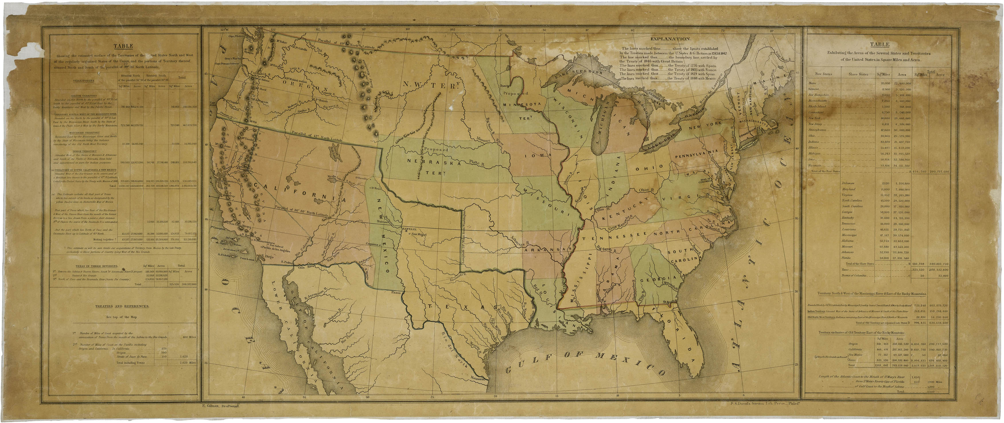
Ephraim Gilman's 1848 map of the United States. (Records of the U.S. House of Representatives, RG 233)
In December 1848, the U.S. General Land Office produced a map of the United States by its principal draftsman, Ephraim Gilman. It displayed all of the existing states, territories, proposed territories, and the area of the Mexican Cession in the southwest acquired by the terms of the Treaty of Guadalupe Hidalgo, which ended the war with Mexico.
The Gilman map was specifically ordered by President James K. Polk to accompany his last annual message to Congress that month. Polk wanted the map to illustrate the territorial gains from the Mexican War, advance his ideas on the development of the newly acquired territories, and address the growing debate in Congress and the nation over the extension of slavery in the territories.
Gilman colored the various areas in pink, light green, and light yellow and featured tables of statistics on the square miles and acreages on the right and left borders. The map is a beautiful artifact on its own, but it is also an intriguing document with features that are not immediately obvious. While the Gilman map appears to be a credible rendering of the United States at mid-19th century, closer inspection reveals serious labeling errors, misspellings, and egregious misplacements of major geographic features. This is surprising because Gilman was an experienced draftsman who had been at the land office at least since 1839.
The Gilman map shows that the 1840s had been an important decade for the expansion of the United States. The Texas annexation by the United States in 1845 brought Texas into the Union as a slave state. In 1846, the British ceded the Oregon Territory south of the 49th parallel: what is now Washington, Oregon, Idaho, and part of and Montana. In the 1848 Treaty of Guadalupe Hidalgo after the Mexican War, Mexico ceded what are now the states of California, Nevada, and Utah and parts of Colorado, Wyoming, Arizona, and New Mexico. The United States now reached coast to coast, a fact that the expansionist President Polk wanted to highlight in this unique but forceful political statement.
Some features of the map readily capture our attention. The shape of Texas looks strongly distorted to the modern eye, making west Texas appear much smaller than it actually is. This distortion reflects Gilman's use of John Disturnell's 1847 "Mapa de los Estados Unidos de Mejico," noted as a source on the left-hand side of his map.
A comparison of Gilman's map with Disturnell's shows an important difference regarding the boundary between New Mexico and Texas. Disturnell's map, which had been used for the Treaty of Guadalupe Hildalgo negotiations, was ambiguous regarding the Texas-New Mexico boundary. Disturnell had the area east of the Rio Grande one color and the area west of the river a different color, strongly implying that everything east of the river lay in Texas, while New Mexico lay only on the western side. But the wording Disturnell used on the map—"Nuevo Mejico" (west of the river) "O Santa Fe" (east of the river)—supported the claim that some of New Mexico lay on the eastern side of the Rio Grande. Gilman's map did away with the ambiguity, not only having different colors on either side of the river but also clearly labeling only the area west of the Rio Grande as New Mexico.

The Disturnell map of 1847. (General Records of the U.S. Government, RG 11)
The Gilman map's rendering of the boundary was part of President Polk's effort to settle a dispute between Texas and New Mexico. In December 1836, the Texas Republic had defined its boundary on the south and west as the Rio Grande from mouth to source and from that point northward to the 1819 Adams-Onís Treaty line between the United States and Spain at 42º N. That boundary claim meant that Santa Fe and all the settled parts of Mexico's northern province of New Mexico would have been part of Texas since they all lay east of the Rio Grande.
Many people in northern states doubted or totally rejected the validity of the Texas boundary claim, and President Polk had wavered on the boundary issue himself during the Mexican War. After Gen. Stephen Watts Kearny's forces occupied New Mexico in August 1847, Polk reassured Texans that the U.S. government was not setting up an adverse claim to that of Texas by establishing a military government at Santa Fe. Then on July 24, 1848, President Polk sent a message to Congress that definitely leaned toward the New Mexicans' claims that their area east of the Rio Grande had never been occupied by the Texans and had always been governed as a province of Mexico until the U.S. conquest in 1846. Polk probably assumed this stance to encourage passage of the Clayton Compromise, a Senate bill that would have established governments in the Mexican session but failed to pass Congress.
In his last annual message to Congress on December 5, 1848, Polk appeared to favor the Texas claim again. Although his message implied that some of New Mexico might extend east of the Rio Grande, he recommended that Congress establish a territorial government only in the areas of New Mexico west of the Rio Grande. The features on Gilman's map reflected Polk's sentiments.
Another politically significant feature of the Gilman map is not initially apparent—a line drawn from the southern boundary of Missouri (the Missouri Compromise line of 1820) to the Pacific Ocean. This rendering suggests Polk's policy regarding the extension of slavery in the territories. In the upper left-hand corner of the map, the line is mistakenly designated as lying at 39º 30' instead of 36º 30', possibly indicating the haste with which the map was prepared and printed. The Missouri Compromise of 1820, extended further west by the Texas annexation resolutions of 1845, had prohibited slavery north of the line and permitted it south of the line.
The beginning of the Mexican War in 1846, with the prospect that the United States would acquire the vast region lying between Texas and the Pacific Coast, prompted northern politicians in Congress to rally behind Pennsylvania Rep. David Wilmot's August 1846 proposal to ban slavery from any territory the United States might acquire from Mexico in the war.
The Wilmot Proviso set off a firestorm of controversy, as southerners responded that they had a constitutional right to carry their slaves into the common territories of the nation. Alternative proposals for resolving the issue of slavery in the territories emerged. One allowed settlers in the territories themselves to determine the slavery question, i.e. popular sovereignty; another left the question to the Supreme Court to determine; and a third called for extending the Missouri Compromise line to the Pacific Coast.
Polk made clear his preference for extending the Missouri Compromise line in a message to the House of Representatives on August 14, 1848, when he signed into law the bill creating a territorial government for Oregon. Polk emphasized the "calming" influence which the 36º 30' line had had on earlier crises over slavery extension, and he strongly urged the application of the same division line to the Mexican Cession. A few months later, in the December 5 annual message, Polk used the Gilman map to reiterate this recommendation to Congress.
The idea of extending the Missouri Compromise to the Pacific would recur in the debate over slavery in the territories. It was championed by southern politicians in 1850 as an alternative to California's admission to the Union as a free state, and the 36º 30' line's extension, excluding California, would become a major suggestion of compromise during the secession crisis of 1860–1861.
Also notable on the Gilman map is its display of boundaries for two "proposed" territories, Minnesota and Nebraska. These features signaled administration support for Senate bills organizing territorial governments in those two areas. Illinois Senator Stephen A. Douglas introduced both bills and chaired the Senate's Committee on Territories. These bills expressed Douglas's vision of America's "manifest destiny," a progressive migration of settlement westward, establishment of territorial governments as settlers advanced (Minnesota) and sometimes in anticipation of settlement (Nebraska), and ultimately the binding of this huge expanse together with a network of railroads from the Atlantic to the Pacific. Polk and his administration ardently championed Douglas's plans, which may explain the inclusion of the two "proposed" territories on Gilman's map, with their boundaries delineated according to Douglas's 1848 bills.
Gilman apparently had a difficult time matching the bill's description of the northeastern part of Minnesota Territory's boundary with the features of his own map. As a result of Gilman's confusion, the map shows a vaguely defined boundary and the use of a different color—yellow—in the northeastern part of Minnesota when he had used green in the western part of the territory. Overall this was the least well-executed portion of Gilman's work. Nor did Gilman draw Wisconsin, the Upper Peninsula of Michigan, and Lake Superior with cartographic exactitude. Neither the Minnesota nor Nebraska territory bills had passed Congress in the earlier session, but Minnesota Territory would achieve organization in 1849. Nebraska's status would become part of the great sectional disruption over slavery expansion in the Kansas-Nebraska Act of 1854.
A curious feature on the western portion of this map is its presentation of Oregon. Congress had organized a territorial government for Oregon in August 1848. On Gilman's map, however, Oregon is not labeled as an organized territory nor given any specific boundary on the east. The area to the east is labeled "N.W. TERy.", or Northwest Territory, even though Congress had not organized any official territory there. Why Gilman did not clearly designate Oregon as a territory with its proper boundaries is a mystery.
Since the other political dimensions of the map are consistent with the administration's policies, it may be that President Polk himself directed that the map be drawn with Oregon only vaguely defined to accommodate southern sensibilities. Southerners had bitterly contested the Oregon Territory bill in the previous session, and they were still angry that the bill had prohibited slavery in a federal territory. The President may have preferred not to remind southerners of their recent congressional defeat by prominently displaying the new, free territory of the northwest.
While some of the omissions, anomalies, and other peculiarities of the map might be traced to its political context, the many serious errors and misspellings on a map that was an important state document indicate hurried preparation. For example, the erroneous listing of the Missouri Compromise line as 39º 30' and the vagueness of the depiction of the proposed Minnesota Territory were not corrected by anyone before this map went to the printer, P. S. Duval, in Philadelphia. That indicates that Ephraim Gilman and his superiors were operating under a tight deadline to get the map and its tables finished in time to accompany Polk's message to Congress.
The number of spelling errors and spelling peculiarities suggest that the drafting of the map was marred by hastiness and carelessness. On the Texas part of the map, "Rio del Norte," another name for the Rio Grande, is given on the map as "Rio del North." El Paso or Paso del Norte becomes "Passo." Matamoros is misspelled "Matamoras," and Nueces River is misspelled "Neuces." Gilman rendered the Sabine River on the map as the "Saline River," although the river is correctly labeled the Sabine in the right-hand table, which was apparently prepared by someone other than Gilman.
A careful examination of the Oregon part of the map reveals more egregious errors, odd omissions, and peculiar spellings. Gilman placed Mount St. Helens south of the Columbia River. By the time Gilman drafted his map, the river emptying into the Columbia River at present-day Portland was widely known as the Willamette River, and the older Indian names had fallen into disuse. Yet Gilman labels that river the "Wahlahmath River" and Fort Walla Walla as "Ft. Wahlah wahlah," although we have not been able to locate other maps of that era with the same usages. It is also curious that the major outpost of Fort Vancouver is not on the map, although it invariably appears in maps made in the 1830s and 1840s of the Pacific Northwest.
We were so intrigued with these errors of omission and commission that we investigated the quality of Gilman's draftsmanship by examining other maps he produced when he was employed by the General Land Office. Those maps reveal high-quality work based on recent surveys but confined to rather limited geographic areas in Illinois, Indiana, Michigan, and Mississippi.
When Gilman got the assignment to draft a map of the United States for President Polk, he had never undertaken cartographic work that ambitious. Since his 1848 map was not based on original surveys and was drafted in haste, we also examined maps from the 1840s at the National Archives, from the Oregon Historical Society, and in published sources that were either readily available to them in the General Land Office or to which they would have had knowledge and access. But the search for clues concerning which maps Gilman might have relied on to draft the 1848 map proved fruitless and yielded no maps full of the same or similar irregularities that are found in Gilman's.
When one examines the Kentucky-Tennessee part of the map, however, the errors appear to have been deliberately inserted. Gilman changed the names of the Cumberland and Tennessee rivers to the "Great Kanawha" and the "Big Sandy," respectively. Those two very prominent rivers had been known and presented on maps for generations as the Cumberland and the Tennessee.
The Kanawha is a river in present-day West Virginia, and the Big Sandy is a river that forms part of the boundary between West Virginia and Kentucky. The mischievous Gilman simply applied the names of these lesser rivers in the area to two major rivers on his map. This experienced draftsman could not have done this by mistake. Since the focus of the map was the western part of it and especially the Mexican Cession, not Kentucky and Tennessee, apparently no one detected the substituted names for the Cumberland and the Tennessee rivers before the map was sent to the printer.
Since there is no evidence that the errors were the results of hurriedly copying from inaccurate maps, we can only speculate on what may have motivated Gilman, an apparently talented draftsman, to falsify the names of two major rivers on his map, repeatedly use incorrect place names, and misplace major geographic features. We conclude that the most likely explanation is that Gilman was a draftsman with an artistic temperament who did not like having to draw his map under a tight deadline and probably under constant pressure from General Land Office Commissioner Richard M. Young to get the job done. Peeved at the pressure, what more appropriate way would Gilman have had to retaliate than by misnaming a few important rivers on his map, especially ones proximate to and within President Polk's home state?
Knowing that the General Land Office was operating under a tight deadline to complete the map and its tables, Gilman would have guessed that no one was going to carefully proofread his work before its printing. And the evidence on the map itself shows that Gilman would have been correct in such an assumption. One can almost imagine him chuckling with delight when no one noticed the errors before the map went to the printer.
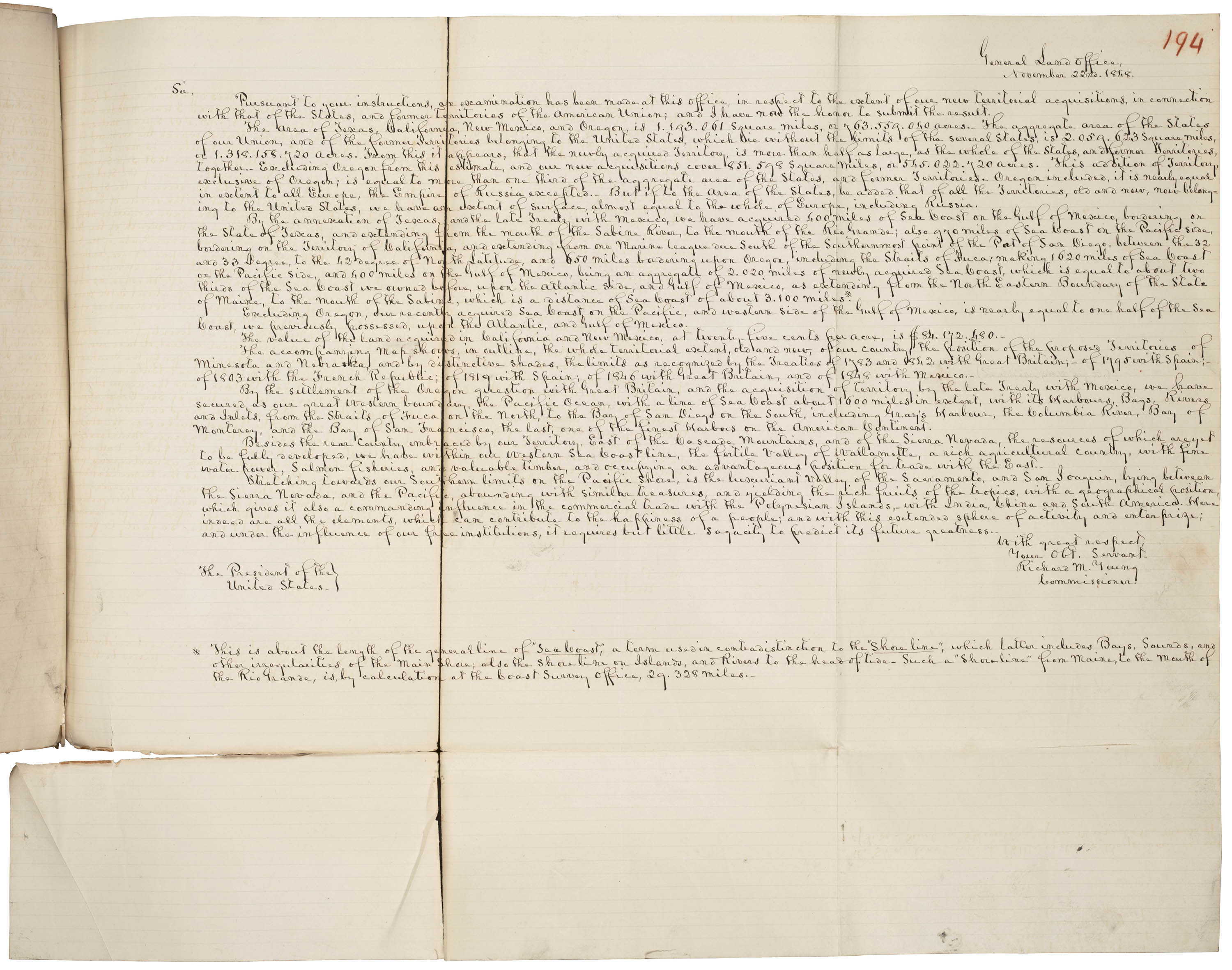
Gilman's map contains statistics gathered from his November 22, 1848, letter from Commissioner Young to Secretary of the Treasury Walker. (Records of the U.S. House of Representatives, RG 233)
While the political meaning and the many inaccuracies of the Gilman map are not readily apparent, neither is its remarkable provenance. Polk's message of December 5, 1848, and many related documents were published as House Executive Document 1 (30th Cong., 2nd sess., Serial 537), with Gilman's map the first among several maps at the end. Tables on either side of Gilman's map contain statistics gathered from a November 22, 1848, letter from Commissioner Young to Secretary of the Treasury Robert J. Walker, discussing the amount and value of the lands acquired from Mexico. Figures from Young's annual report dated November 30, 1848, concerning acreages of some of the newer states appear in the right-hand table of the map. Young had personally reported to President Polk on November 24 about the dimensions of the newly acquired lands and gave Polk a copy of Gilman's map. Polk stated in his diary that he would employ the statistics of Young's "Report" in his upcoming annual message. The report Polk referred to was the November 22 letter from Young to Walker, not the annual report. President Polk did use Young's statistics in his message but quoted a few of the figures slightly in error. The statistics on Gilman's map agree with those in Young's letter to Walker.
The copy of Gilman's map preserved at the Center for Legislative Archives at the National Archives is an extraordinary document because it is somewhat corrected and updated from the version originally published in the Congressional Serial Set and was referred to during congressional debate over the Compromise of 1850.
Whoever used the copy of Gilman's map now in the Archives corrected the Missouri Compromise line error in the upper left-hand corner by crossing out 39º30' and writing in 36º30'. He also sketched in, or had a draftsman sketch it in for him, the boundary line of California as proposed by its state constitutional convention of 1849. The alterations were probably made by a congressman or senator in early 1850 in preparation for a speech.
An examination of the map in January 2008 by the National Archives conservation laboratory revealed that the blue line indicating the California boundary was drawn by someone after February 13, 1850, the date President Zachary Taylor sent official copies of the California constitution to the House and Senate. Yet whoever inserted the California boundary did not sketch in the boundary line between Utah and New Mexico or between New Mexico Territory and Texas, both of which were defined by Congress in bills during August and September 1850 as part of the Compromise of 1850. The absence of these lines strongly suggest that the map was altered after February 13 but before September 1850.
Could someone have altered this copy of the Gilman map prior to February 1850, possibly during the short second session of Congress in December 1848–March 1849? No. Among the various bills that proposed to organize either a state or territorial government for California, no boundary provision matched those defined by the California constitution later in 1849 and drawn on the map. If a member of Congress was responsible for altering the Archives copy of the Gilman map in the first session of the 1849–1851 Congress, who could it have been? Only Louisiana's Senator Solomon W. Downs specifically referred to Gilman's map in a speech on February 19, 1850, during debate on the compromise proposals previously presented by Senator Henry Clay of Kentucky; Downs used the map to point out that Clay's proposal on Texas boundaries would have cut off northern Texas from the state.
Others who referenced the map pointed to its statistical tables. Most citations of statistics from the map were made in the House during speeches by northern representatives supporting the admission of California as a state. On March 11, Rep. Orin Fowler (W-MA) quoted a few statistics from the tables on both sides of the map, and on June 3 Rep. Peter H. Silvester (W-NY) quoted a few aggregate statistics from the right-hand table. Two congressmen, Rep. Samuel R. Thurston (D-OR) on March 25 and Rep. Jesse C. Dickey (W-PA) on June 6, both copied much of the entire right-hand table into their pro-California statehood speeches. One figure that both cited, which was not on Gilman's map, was an estimate of approximately 145,000 square miles for the area of California as defined by its constitution's boundaries. Thurston's speech, at least the printed version, occupied parts of 10 pages in the Congressional Globe; it analyzed much of the California constitution and quoted its section on boundaries. In our opinion, if a member of Congress was responsible for the insertion of the California boundary on the Archives copy of the Gilman map, that member was most likely Samuel Thurston of Oregon. No member of the Texas delegation, all Democrats, cited the Gilman map in support of their state's claim to all the territory east of the Rio Grande, although the map clearly supported that claim. When the Texans did mention maps in the first session of the 1849–1851 Congress, they cited Disturnell's, which had authority by virtue of its having been the map used in the Treaty of Guadalupe Hidalgo negotiations, or a more recent and more accurate one based on actual surveys by the Texas General Land Office, the Jacob de Cordova-Robert Creuzbaur map of August 1848. Senator Sam Houston did not himself refer to the Cordova-Creuzbaur map in this session but had strongly promoted it as an accurate map of Texas during the second session of the 30th Congress in 1848. The two maps the Texans cited simply served their purpose of defending the Texas boundary claim in debate during 1850, and they saw no need to also cite the Gilman map.
Ephraim Gilman's 1848 map proved more useful in Congress for its statistical data than for its colorful depiction of U.S. geographic contours. But with its presentation of New Mexico lying unambiguously west of the Rio Grande, the map does illustrate the final tilt of the Polk administration toward the validity of Texas's 1836 claim.
The map also reflects President Polk's view that the best solution to the sectional crisis over slavery in the territories was the extension of the Missouri Compromise line to the Pacific Coast. The marking of the proposed California state boundary on the Archives copy of the map used during the course of the debate over the Compromise of 1850 makes it a unique document.
Finally, the Gilman map illustrates how much of the nation's history a single document can reveal and how many mysteries the draftsman embedded in this fascinating example of 19th-century cartography.
Mark J. Stegmaier is professor of history at Cameron University in Lawton, Oklahoma, where he has taught since receiving his Ph.D. from UCSB in 1975. He is the author of Texas, New Mexico, and the Compromise of 1850: Boundary Dispute and Sectional Crisis (Kent, OH: Kent State University Press, 1996) and co-author of James F. Milligan: His Journal of Fremont's Fifth Expedition, 1853–1854: His Adventurous Life on Land and Sea (Glendale, CA: Arthur H. Clark Co., 1988).
Richard T. McCulley is the historian at the Center for Legislative Archives at the National Archives and Records Administration, Washington, D.C. He received his Ph.D. in U.S. history from the University of Texas at Austin and was a lecturer and research associate at the Lyndon B. Johnson School of Public Affairs. He is the co-author of White House Operations: The Lyndon Johnson Presidency (Austin: University of Texas Press, 1986) and author of Banks and Politics during the Progressive Era (New York: Garland Press, 1992).
Note on Sources
The map that is the subject of this article, Map of the United States Including Western Territories, December 1848, can be found in RG 233, Records of the U.S. House of Representatives, Center for Legislative Archives, National Archives and Records Administration (NARA). The Disturnell map of 1847 is in General Records of the United States Government, Record Group (RG) 11, NARA.
Information on Ephraim Gilman is from the United States Official Register, 1839–1851 at the National Archives; 1840 and 1850 U.S. Censuses for the District of Columbia, National Archives Microfilm Publication M704 and M432, respectively; and the New York Times, February 23, 1853.
On President James K. Polk's request for the map and his statements based on the Gilman map and tables, see Milton M. Quaife, ed., The Diary of James K. Polk During His Presidency, 1845 to 1849 (Chicago: A.C. McClurg & Co., 1910), and James D. Richarson, A Compilation of Messages and Papers of the Presidents, 1789–1897, volumes 4 and 5 (Washington: G.P.O., 1897).
Correspondence relating to the Gilman map is in the U.S. Serial Set, U.S. Congress, House of Representatives, H. Ex. Doc. 1, 30th Congress, 2nd session, vol. 537, 1849. The floor debates in the House of Representatives that referenced the Gilman map and tables are available in the Congressional Globe, 31st Congress, 1st session, 1850.
The published sources most helpful for understanding the political context of the Gilman map are: Stegmaier, Texas, New Mexico, and the Compromise of 1850, cited above, and Stegmaier, "The Guadalupe Hidalgo Treaty as a Factor in the New Mexico-Texas Boundary Dispute" in John P. Bloom, ed., The Treaty of Guadalupe Hidalgo: Papers of the Sesquicentennial Symposium, 1848–1998 (Las Cruces, NM: Doña Ana Co. Historical Society and Yucca Tree Press, 1999), pp. 31–33. See also Robert W. Johansson, Stephen A. Douglas (New York: Oxford University Press, 1973); Paul H. Bergeron, The Presidency of James K. Polk (Lawrence: University Press of Kansas, 1987); Chaplain W. Morrison, Democratic Politics and Sectionalism: The Wilmot Proviso Controversy (Chapel Hill: University of North Carolina Press, 1967); and Allan Nevins, Ordeal of the Union, volume 1, Fruits of Manifest Destiny, 1847–1852 (New York: Charles Scribner's Sons, 1947).
The authors would like to thank National Archives and Records Administration archivists Constance Potter for editorial suggestions and for furnishing biographical information on Ephraim Gilman; Richard H. Smith of the Cartographic Division for assistance in our examination of the cartographic work of Gilman; and William Davis of the Center for Legislative Archives. We also thank NARA conservationist Yoonjoo Strumfels for conducting a very detailed analysis of the map. We also appreciate Scott Daniels, research librarian at the Oregon Historical Society, who conducted at our request a search of Oregon maps drawn before 1850.