![]()
The Search for the Site of the Sand Creek Massacre
Summer 2001, Vol. 33, No. 2
By Christine Whitacre

A modern view of the Sand Creek site. (National Park Service)
On November 29, 1864, approximately seven hundred soldiers led by Col. John Chivington attacked a Cheyenne and Arapaho village in what is now southeastern Colorado. The village, made up of around one hundred lodges, was on the banks of a meandering, intermittent stream known as Sand Creek. Under the leadership of Cheyenne chief Black Kettle, about five hundred Cheyenne and Arapaho people were camped at the site, believing that they were not only at peace with the U.S. government but also under its protection. Nevertheless, Chivington's troops, made up of volunteers from the Colorado First and Third Cavalry, launched a surprise dawn attack that left at least 150 Cheyennes and Arapahos dead—mostly women, children, and the elderly. During that afternoon and the following day, the soldiers followed up the massacre by committing atrocities on the dead before withdrawing from the field. Upon their return to Denver, the soldiers received a heroes' welcome, which included a display of scalps and body parts that had been taken from the Indian victims. Soon, however, the Sand Creek Massacre was recognized for what it was: a national disgrace that was condemned by three separate federal investigations.1
Nearly 135 years after the event, Senator Ben Nighthorse Campbell (R-Colo.), the only Native American member of Congress and a Cheyenne descendant of survivors of the Sand Creek Massacre, sponsored legislation that began the process of memorializing the massacre site. Senator Campbell introduced Senate Bill 1695, which was signed by President Bill Clinton on October 6, 1998, as Public Law 105-243. Known as the Sand Creek Massacre National Historic Site Study Act of 1998, the legislation directed the National Park Service (NPS)—in consultation with the Cheyenne and Arapaho Tribes of Oklahoma, the Northern Cheyenne Tribe, the Northern Arapaho Tribe, and the State of Colorado—to complete two tasks. First, the National Park Service was to verify the location and extent of the Sand Creek Massacre site. Indeed, a lack of conclusive evidence as to the site's location had been the major obstacle to earlier efforts to designate the site. Second, the National Park Service was to evaluate a range of management alternatives for the site, including the feasibility of making the Sand Creek Massacre site a unit of the National Park System. Congress also mandated that the project be completed within eighteen months.
The National Park Service Sand Creek Massacre project team took a wide-ranging multidisciplinary approach to finding the massacre site. As part of the site location effort, Cheyenne and Arapaho descendants of the Sand Creek Massacre, a number of whom were members of the project team, told stories of the massacre that had been handed down to them through the generations. Historians researched maps, diaries, reminiscences, and congressional and military investigative reports for information that might shed light on the location of the massacre. The National Park Service also held public open houses in southeastern Colorado, encouraging local residents to come forward with information, including artifacts found on their land that might be evidence of the massacre. Historical aerial photographs, the earliest dating from the 1930s, were examined for evidence of trails leading to and from the massacre site. Before the archaeological survey got going in May 1999, the NPs team conducted a geomorphological assessment of Sand Creek that identified, through an analysis of soil samples, those specific landforms from which 1864-era artifacts might be recovered.
Archival documentation at the National Archives played a significant role in the successful completion of the Sand Creek Massacre project—which led, ultimately, to Sand Creek's authorization as a national historic site in November 2000. A map drawn by U.S. Army lieutenant Samuel Bonsall in 1868 that was found by archivist Scott Forsythe in the National Archives and Record Administration–Great Lakes Region, was integral to the discovery of the Sand Creek Massacre site. Jerome Greene, NPs lead historian for the site location study, called the map "the most important document yet located to convincingly posit the site of the Sand Creek Massacre."2
Historical Background
The Sand Creek Massacre is one of the most emotionally charged and controversial events in American history; it is also, as Jerome Greene has noted, "a tragedy reflective of its time and place."3 Although army reports of the massacre are grouped with the official records of the Civil War, Sand Creek more closely reflects the vast cultural, social, and political changes that were taking place in the West during the mid-nineteenth century, far removed from the battlefields of Gettysburg and Manassas. The tragedy at Sand Creek was the culmination of several forces, including the Colorado Gold Rush, the ambitions of local politicians and military leaders, the clash of cultures on the western plains, and the claims of different groups of people to the same land.
By the time the Civil War had begun, the Cheyenne and Arapaho people had been on the western plains for decades. Under the terms of the 1851 Treaty of Fort Laramie, Cheyenne and Arapaho territory included much of the front range of Colorado. But major gold strikes in the mountains west of Denver in 1858 and 1859 precipitated a tide of Euro-American immigration. In 1859 William Bent, the well-known trader who also served as the Colorado and Arapaho agent in Colorado, called upon the U.S. government to better define the territorial rights of the Indians in the area. The result was the 1861 Treaty of Fort Wise, by which the Cheyennes and Arapahos surrendered most of their land and received instead a much smaller, triangular-shaped tract along and north of the upper Arkansas River in southeastern Colorado. Sand Creek, also known as Big Sandy Creek, formed the eastern border of this reservation.
But not all Cheyennes and Arapahos recognized the Treaty of Fort Wise, and many refused to abide by it. By the summer of 1864, a number of conflicts between Euro-Americans and Indians heightened an already tense situation within Colorado Territory. Colorado's territorial governor, John Evans, as well as Col. John Chivington, who headed the U.S. Army military district in Colorado, interpreted the attacks upon white settlers as proof that the Indians were preparing for war, even though evidence indicates that they were the actions of warriors acting beyond the control of their chiefs. On June 11, 1864, Arapaho warriors attacked and murdered the Hungate family, thirty miles from Denver. The public display of the family's bodies, which included two young children, terrified Colorado's citizens, many of whom left their ranches to seek protection within the walls of Denver's mint. Two weeks later on June 27, Governor Evans issued a proclamation to all "Friendly Indians of the Plains" to present themselves to assigned military posts. The Cheyennes and Arapahos who wanted to be at peace with the government were told to go to the military authorities at Fort Lyon, which was along the Arkansas River near present-day Lamar, Colorado. Meanwhile, Governor Evans began preparing for military action. On August 11, Evans received permission from federal authorities to raise a regiment of hundred-day U.S. Army volunteers, designated the Third Colorado Cavalry under the command of Colonel Chivington. Also in August, Evans issued a proclamation that contradicted his earlier one to the "Friendly Indians of the Plains," now calling upon citizens to kill all Indians and seize their property.
At the same time that Evans and Chivington were assembling military forces, Cheyenne and Arapaho chiefs were attempting to negotiate a peace settlement. Cheyenne chief Black Kettle contacted Maj. Edward Wynkoop, the commander at Fort Lyon, of his desire for peace. In response, Wynkoop led his command of First Colorado Cavalry to meet Black Kettle and the Arapaho leader, Left Hand, at the big timbers of the Smoky Hill River near Fort Wallace, Kansas. Here, the Cheyenne and Arapaho chiefs turned over several white captives and consented to meet with Evans and Chivington. That meeting took place on September 28 at Camp Weld, outside of Denver. Although the Indians departed Camp Weld believing that they had negotiated a peace settlement, Governor Evans soon notified officials in Washington of the tribes' continued hostilities and noted that "the winter . . . is the most favorable time for their chastisement."4
In late October and early November, the Arapahos and Cheyennes began arriving at Fort Lyon to comply with what they believed were the conditions of the peace settlement. Maj. Scott Anthony, the fort's new commander, instructed the Indians to camp at an area approximately forty miles north-northeast of the fort. Simultaneously, however, the army was already initiating its attack. On November 14, Chivington's troops began marching out of Denver. The troops reached Fort Lyon midday on November 28. At approximately 8 p.m., now joined by troops from Fort Lyon, Chivington's men began an all-night ride towards the Cheyenne and Arapaho encampment on Sand Creek, following an old Indian trail that led to the site.
At dawn on November 29, Chivington's forces, equipped with four twelve-pounder mountain howitzer guns, attacked the village. Many of the villagers who survived the initial attack fled upstream to the north. Approximately one mile above the village, according to most accounts, the Indians sheltered themselves in hastily dug trenches along the banks of the creek. The soldiers followed the Indians to this area, known as the "sandpits," bringing with them at least two mountain howitzers. By day's end, at least 150 Indians had been killed. On the army's side, ten soldiers died. Afterwards, Chivington ordered his men to plunder and burn the village. After the massacre, Cheyenne and Arapaho survivors began making their way northeast to the camps of their kinsmen along the forks of the Smoky Hill River.
Previous Efforts to Locate the Sand Creek Massacre Site
Although most historic accounts of the Sand Creek Massacre placed it at the "Big South Bend" of Sand Creek, its exact location became obscured over time. As Mildred Red Cherries of the Northern Cheyenne noted at project meetings, the Sand Creek Massacre became "lost," even to the descendants of those who had survived the attack. The massacre site was left unmarked and, by the turn of the century, there was little evidence of the terrible events of November 29, 1864. In 1908, army veterans who had participated in the massacre planned a reunion at the site. However, upon reaching the banks of Sand Creek, even they could not agree on its location.
On August 6, 1950, the Colorado Historical Society erected a Sand Creek Massacre historical marker on State Highway 96 near the town of Chivington, Colorado. On that same day, the historical society participated in a second dedication ceremony approximately fifteen miles to the north, on property now owned by Bill and Jredia Dawson. Here, overlooking an approximate 90-degree bend of Sand Creek, the local community placed a second marker, designating it as the site of the massacre. Tribal members also returned to the area, using their traditional tribal knowledge and oral histories to identify the massacre site. In 1978 the Arrow Keeper of the Cheyenne Tribe recognized what is now referred to as the Dawson South Bend as the Sand Creek Massacre site when he blessed it as "Cheyenne earth."
Still, there were those who disagreed that the site had been found. Many observers were troubled by the lack of physical evidence of either the village site or the military's ammunition. In particular, critics questioned why no evidence of Civil War-era ammunition, including twelve-pounder mountain howitzer ordnance, had been found at the Dawson South Bend. The Sand Creek Massacre was the only Civil War–era event in Colorado in which the army used such guns, and many believed that the discovery of howitzer-related artifacts would offer significant proof of the site location.
In the early 1990s, amateur archaeologists and metal detector hobbyists who had surveyed the Dawson South Bend, but had not found artifacts associated with the Sand Creek Massacre, approached the Colorado Historical Society with their findings. In response, the Colorado Historical Society initiated a project to identify the location of the massacre. In 1994 the society asked Richard Ellis of Fort Lewis College, Durango, Colorado, to develop a project to verify the location of the Sand Creek Massacre. As an important first step, Ellis and the Colorado Historical Society began consulting with descendants of Cheyenne victims of the Sand Creek Massacre. In 1997 Ellis also asked archaeologists Douglas Scott of the National Park Service, William Lees of the Oklahoma Historical Society, and Anne Bond of the Colorado Historical Society, in cooperation with other volunteers and metal-detector organizations, to conduct reconnaissance-level archaeological surveys of two possible Sand Creek Massacre sites. The team surveyed the "vee" of the Dawson South Bend as well as another large bend of Sand Creek, often referred to as the "North Bend," which was approximately ten miles north of the Dawson South Bend. But the state-funded Fort Lewis College project was unable to conclusively identify the location of the Sand Creek Massacre site. No 1864-era artifacts were found in the North Bend, and only twelve 1864-era items were found in the Dawson South Bend, either through the 1997 survey or later by the landowner. As a result, although there was now growing interest in designating the Sand Creek Massacre as a national historic site, there was still no definitive physical evidence, or consensus, regarding its location.
National Park Service Efforts to Locate the Site
Following the passage of the Sand Creek Massacre National Historic Site Study Act in October 1998, the responsibility for the Sand Creek Massacre project was delegated to the Intermountain Regional Office of the National Park Service, headquartered in Denver. A project team was assembled that included historians, ethnographers, archaeologists, geomorphologists, and other disciplines.5
As mandated by Congress, the major goal of the Sand Creek Massacre site location study was to map the "location and extent" of the Sand Creek Massacre. One of the team's first tasks was to identify all potential locations of the massacre. The methodology was based on two basic principles. First, all possible sites would be evaluated according to the evidence; there was no presumption as to the "right" location of the massacre site. Second, the project team would follow four major lines of evidence: 1) historical research, 2) oral histories, 3) traditional tribal knowledge, and 4) physical evidence of the site, as determined by reconnaissance-level archaeological survey.
The archaeological survey was scheduled for May 1999. Evaluation of oral histories, traditional tribal methods, aerial photographs, historical research, and geomorphology was to be completed first. The archaeological survey could then focus on those areas that were the most likely locations of the Sand Creek Massacre and which were most likely to have physical evidence of the massacre.
Historical Research
Historical research efforts involved examination of a large number of published and manuscript historical maps for information about streams, trails, roads, land use, ownership, and other data that might help pinpoint the site. Among the most important sources of information were four maps drawn or annotated by George Bent, a mixed-blood Cheyenne survivor of the massacre. One of the maps, drawn by George Hyde and annotated by George Bent, places the Sand Creek Massacre in the North Bend of Sand Creek. As noted earlier, the 1997 state-funded archaeological survey of this area uncovered no massacre-related artifacts.6 The second map, also drawn by Hyde and annotated by Bent, places the massacre site below the confluence of Rush and Sand Creeks, approximately twenty miles south of the Dawson South Bend.7 The remaining two maps, which were drawn by George Bent approximately forty years after the Sand Creek Massacre, focus on the massacre site itself. These maps show the placement of Indian encampments within the village, the location of the sandpits area in relationship to the village, and the troop movements. These two maps, one of which is in the collection of the Oklahoma Historical Society and the other in the archives at the University of Colorado Library at Boulder, also show that the massacre occurred near a 90-degree bend of Sand Creek, a configuration that greatly resembles the Dawson South Bend.8
In addition to the Bent maps, a manuscript map drawn by U.S. Army lieutenant Samuel Bonsall in 1868 also contained significant information that pertained directly to the location of the Sand Creek Massacre.9 In 1992, while processing records associated with nineteenth-century military activities in the Trans-Mississippi West, archivist Scott Forsythe found the Bonsall map in Record Group 77, Records of the Army Corps of Engineers, in the National Archives and Records Administration–Great Lakes Region in Chicago. "It is unusual that records such as the engineering officer records of the Department of the Platte would have found their way into a regional archives facility but, through unknown circumstances, these records ended up with the Chicago district of the Corps of Engineers and were transferred into the holdings of the Great Lakes Region," noted Forsythe. The discovery of the Bonsall map was memorable for Forsythe, because he was well acquainted with Sand Creek and understood the map's reference to "Chivingtons Massacre." A few years after finding the Bonsall map, Forsythe learned of the upcoming State of Colorado–Fort Lewis College project to locate the site of the Sand Creek Massacre. Forsythe subsequently contacted the Colorado Historical Society and, in 1996, sent them a copy of the Bonsall map.10 In 1998, when the National Park Service efforts to locate the Sand Creek Massacre site began, Colorado state historian David Halaas gave a copy of the map to NPs historian Jerome Greene.
The Bonsall map was drawn by 2nd Lt. Samuel W. Bonsall, Third Infantry, who was stationed at Fort Lyon in 1868; the map documents the route of Bonsall's detachment of eleven infantry soldiers from Fort Lyon to Cheyenne Wells, Colorado. Bonsall and his men were escorting Lt. Gen. William T. Sherman east following a tour of frontier sites. The map was prepared in June 1868, within four years of the Sand Creek Massacre, in accordance with U.S. Army regulations. Rendered in the form of a strip map and journal, the map is graphically detailed with regard to landmarks and place names, including time and mileage readings. The map shows the site of "Chivingtons Massacre" in relative placement to two landmarks. Bonsall placed "Chivingtons Massacre" between a point, south of the massacre site, where the road from Fort Lyon crossed Sand Creek, and a point approximately six miles north from it, where that same road branched into "three forks." Between these points, the lieutenant drew a bold line, approximately two miles long, representing the extent of the massacre site.
The significance of the Bonsall map became even more apparent when it was compared to historical aerial photographs of the massacre site. Art Ireland, an NPs archaeologist on the project team, examined a series of historical and contemporary aerial photographs for evidence of landmarks that had been delineated on the Bonsall map. In particular, Ireland searched for segments of the historic trail that the army may have traveled between Fort Lyon and the massacre site, including the point at which it crossed Sand Creek. Ireland also examined the photographs for evidence of "three forks," that point six miles north of the massacre at which the trail branched into three separate routes.
The earliest aerial photographs of the Sand Creek area were taken in 1936–1937 by the Soil Conservation Service.11 These photographs, taken nearly seventy years after the massacre, precisely confirm the "three forks" point as delineated on Bonsall's map. The photographs, which indicate that the area had changed relatively little since the time of the account, also clearly show a road leading to and from Fort Lyon. Thus, prior to the archaeological survey of the Sand Creek Massacre site, Greene—primarily based on an analysis of the Bonsall map and its comparison to the 1936–1937 aerial photographs—concluded that the village attacked by Chivington's troops on November 29, 1864, was approximately one mile north of the "vee" of the Dawson South Bend, the site traditionally believed to be the massacre site.
Oral Histories
The oral histories of descendants of the Cheyenne and Arapaho survivors of the massacre were significant sources of information. From the beginning of the project, the National Park Service had been committed to the collection of oral historical data as one of the primary lines of evidence in locating the Sand Creek Massacre site. Between April 1999 and February 2000, thirty-two Cheyenne and Arapaho descendants of survivors of the Sand Creek Massacre gave oral history accounts, which they permitted to be recorded and transcribed.12
The Sand Creek Massacre oral history project specifically focused on information that would help identify the location of the massacre site. In particular, descendants were asked specific questions about topics such as geographic landforms, physical descriptions of the size and extent of the Indian encampment, and information on trails that led to the site. Several geographic elements recurred in the oral history interviews. Among these was the often-stated need for the campsite to have been located close to water, both for the people and for their horses. In particular, a number of interviewees said that Cheyennes always followed watercourses and always camped by water. Many said that there was no flowing water in Sand Creek at the time of the massacre. While horses could have drunk from the standing pools, oral history accounts indicated that people would have dug for water or used spring water. Several people emphasized the importance of an available spring as a source of drinking water, noting that it is against traditional Cheyenne belief to drink from a source of water that had been standing overnight. The information on the water source was of particular significance because an extant spring is approximately two miles east of the Dawson South Bend. The proximity of this spring supported the Cheyenne belief that the Dawson South Bend was the area of the Indian encampment.
Interviewees also revealed information on the proximity of the sandpits area to the village site. Several people recounted that the majority of people in the village were women, children, and the elderly, who could not have run very far from their lodges before seeking out hiding places. Other stories noted the presence of rocky hiding places. In particular, Northern Arapaho interviewees gave accounts of limestone outcroppings in the area, which survivors had used as shelter. Several people mentioned the presence of hills and trees near the massacre site. Interviewees also provided details about the size of the encampment, in terms of both geographic space and number of lodges. Many also discussed the makeup of the encampment, particularly the relative placement of the Cheyenne and Arapaho groups. However, with important exceptions—such as the description of the massacre site provided by Southern Cheyenne descendant Laird Cometsevah—geographic details of the massacre site were generally nonspecific as to exact location. (Some interviewees expressed a reluctance to provide more detail because of the often-stated fear of government retribution, extreme emotion, or the belief that the stories belong to the families only.) As NPs ethnographer Alexa Roberts observed, geographic details in the oral histories of the Sand Creek Massacre were peripheral to the descriptions of the atrocities committed during that event. Overwhelmingly, the oral histories provided powerful testimony to the horrors of the events of November 29, 1864, and the devastating effects of the massacre on families and the tribes that linger to this day. Although accounts of physical features associated with the site varied among the oral history accounts, every story shared "the sense of chaos, running, scattering, horror, fear, and blood."13
Traditional Tribal Methods
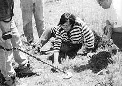
Mildred Red Cherries uncovers artifacts from the Sand Creek Massacre site. (National Park Service)
As part of the site location study, Cheyenne and Arapaho spiritual leaders and elders also agreed to employ traditional tribal methods to help determine the location of the massacre. Descendants of survivors of the Sand Creek Massacre had often stated that there are ways other than oral histories or written accounts by which they know of the location of the massacre site. Among the traditional ways mentioned most frequently is sensing a spiritual presence or hearing the voices of women, children, horses, or other animals while present on the site. The National Park Service understood that these methods were often private in nature and could not be used effectively in the presence of non-Indians but agreed to assist in these investigations to whatever extent possible.
The Sand Creek Massacre, Volume One: Site Location Study includes an account given by Robert Toahty, a descendant of an Arapaho survivor of Sand Creek. Based on visions that he saw at the site, Toahty believes that the people killed at Sand Creek are scattered for about two miles in the creek bed north of the stone monument in the vicinity of the Dawson South Bend. Other descendants noted hearing the voices of both people and horses. Southern Cheyenne descendant Laird Cometsevah described hearing voices in the Dawson South Bend while on site during both the 1997 and 1999 archaeological field sessions. And, as noted earlier, the Cheyenne Arrow Keeper blessed the Dawson South Bend as "Cheyenne earth" in 1978, thereby designating it as the Sand Creek Massacre site.
Archaeological Survey
By the time the archaeological survey began in May 1999, a number of draft reports—including the historical documentation report by Jerome Greene—had been completed. The results of these efforts, as well as preliminary information from the oral history interviews and traditional tribal methods, indicated five areas as potential sites of the Sand Creek Massacre. The research also indicated that the massacre did not take place in a small isolated area. According to a variety of accounts, the massacre was a running engagement that occurred along a stretch of Sand Creek approximately five to six miles in length. Encompassed within this area were the Indian village site, the sandpits, and areas of Indian and troop movements.
An underlying assumption of the site location study was that the Cheyenne and Arapaho village site, and possibly the sandpits area, might contain enough intact archaeological remains to identify the massacre site. Historical archaeology has been very successful in verifying the location of various battle sites throughout the Trans-Mississippi West. The investigations at Sand Creek used metal detecting and other remote-sensing applications to identify cultural material associated with the Indian village and the military. Remote-sensing equipment minimized disturbance to the landowners' pastures and fields and to any human remains below.
In preparation for the archaeological investigations, the National Park Service commissioned a geomorphological survey of the Sand Creek area. Geomorphologists analyzed soil samples to determine if a site was likely to contain physical evidence of the 1864 massacre and if it contained a layer of soil dating from the 1864 era. Dating the soil layers was particularly important along Sand Creek, as many people speculated that the layer that contained the Sand Creek Massacre artifacts might have been lost to flooding and wind erosion. Test results indicated that the alignment of Sand Creek had not changed substantially over time, eliminating that as a factor in locating the site. In addition, the geomorphologists concluded that the area in the vicinity of the Dawson South Bend had not been substantially disturbed by erosion or agricultural practices, at least not to the extent that such activities would have destroyed all archaeological evidence of the Sand Creek Massacre.
In May 1999, NPS archeologist Douglas D. Scott oversaw the archaeological reconnaissance survey of several areas along Sand Creek. The investigation, which included NPS staff, volunteers, landowners, and several members of the Cheyenne and Arapaho tribes, resulted in the collection of nearly four hundred artifacts that, according to archaeological analysis, confirmed the location of Black Kettle's village in the area projected by Jerome Greene's historical research. The greatest numbers of artifacts were concentrated in Section 24, Township 17 South, Range 46 West, at the northern edge of the Dawson South Bend. Found here were Civil War–era tin cups, cans, horseshoes, horseshoe nails, plates, bowls, knives, fork, spoons, barrel hoops, a coffee grinder, a coffee pot, iron arrowheads, bullets, and case shot fragments. As archeologist Douglas Scott observed, the majority of the artifacts are objects typical of Native American encampments of the nineteenth century and, when compared to lists of trade and annuity goods known or requested for distribution to the Cheyennes and Arapahos in southern Colorado, "demonstrate a striking degree of concordance."14 The team also found a variety of iron objects modified for Native American uses. These artifacts include knives altered to awls, iron wire altered to awls, fleshers or hide scrapers, strap iron altered by filed serrations as hide preparation devices, and several iron objects altered by filing to serve an as-yet unidentified cutting or scraping purpose. Cheyenne and Arapaho members of the archaeological team identified many of these artifacts. Among them was a crescent-shaped object identified as a Cheyenne man's breast ornament.15
Many of the artifacts showed evidence that they had been intentionally broken, a pattern of destruction typical of U.S. Army actions of the period. The arms and ammunition that were found are likewise consistent with those carried by the cavalry units that participated in the massacre. In particular, the archaeological fieldwork uncovered fragments of twelve-pounder mountain howitzer shells.
Identification of the Location and Extent of the Sand Creek Massacre Site
By fall of 1999, the end of the first project year, the National Park Service believed that the first task mandated by the Sand Creek Massacre National Historic Site Study Act—identifying the location and extent of the massacre site—had been accomplished.
Jerome Greene's review of historical documents, primarily the 1868 Bonsall map, had indicated that Section 24, Township 17 South, Range 46 West, was the likely site of the village. And, indeed, the archaeological survey uncovered approximately four hundred artifacts in a concentrated area within this section, the type and distribution of which are consistent with an Indian village of approximately five hundred people. Also within this artifact concentration—among the shattered plates, utensils, hide scrapers, awls, and trade items that had once been part of the daily lives of the Cheyennes and Arapahos who had camped here—the survey team found evidence of the ammunition and weapons used to attack and kill them. Although no conclusive evidence of the sandpits was found during the 1999 archaeological survey, historical accounts indicate they were anywhere from three hundred yards to two-plus miles upstream of the village, but most likely at around one-quarter mile to one mile. As such, Greene concluded that the probable location of the sandpits is in Sections 13 and 14, Township 17 South, Range 46 West. Among the artifacts that had been found in this area were shell fragments from twelve-pounder mountain howitzers, which were known to have been used in the sandpits area.16
However, at an October 1999 project meeting, the Cheyenne tribal representatives to the project team, as well as the representative of the State of Colorado, disagreed with the conclusions of the National Park Service as to the location of the village and the sandpits. As noted earlier, Cheyenne tradition held that the village lay within the "vee" of the Dawson South Bend, not at its northern edge, where the artifact concentration was found. Cheyenne representatives and Colorado state historian David Halaas also pointed to the two sketch maps drawn by George Bent that showed the Indian encampment as being within the "vee" of the bend. While NPS historians found the Bent maps to be valuable tools in terms of placing the relative locations of specific encampments, they also believed that they lacked scale and immediacy to the event. Moreover, while the National Park Service believes that the placement of the village at the northern edge of the Dawson South Bend does not conflict with most oral history accounts of the massacre, that view is not shared by all of the tribal representatives to the project. The Cheyenne and Arapaho Tribes of Oklahoma and the Northern Cheyenne Tribe believe that the oral histories are strong evidence that the village is located in the "vee" of the Dawson South Bend.
If, as the representatives of those tribes believe, the village was in the "vee" of the Dawson South Bend, then what is the concentration of artifacts approximately one mile north in Section 24? Laird Cometsevah, great-grandson of Cometsevah, who was a survivor of the Sand Creek Massacre, believes the artifacts may be evidence of the sandpits, or perhaps a later Euro-American settlement in the area. Others believe the artifacts may be the northern edge of the village, the area where the soldiers bivouacked after the massacre, or both.
The Northern Arapaho representatives of the project team concur with the conclusions drawn by the National Park Service with regard to the location of the village site and the sandpits. However, the Cheyenne and Arapaho Tribes of Oklahoma and the Northern Cheyenne Tribe maintain that additional archaeological survey work will provide proof that the village was, indeed, within the crux of the Dawson South Bend. While the distance between these two contested village locations is less than one mile—and are both located within the Dawson South Bend—they also reflect a much wider gulf between interpretations of "truth" and of scientific evidence versus cultural knowledge. They also represent, in a broader sense, a continuing distrust of the U.S. government by tribal members, a relationship at least partially rooted in the Sand Creek Massacre itself.
While there was no consensus regarding these issues, all members of the project team also recognized the importance of the larger effort to memorialize and protect the Sand Creek Massacre site. Ultimately, the entire team—the National Park Service, the Cheyenne and Arapaho Tribes of Oklahoma, the Northern Arapaho Tribe, the Northern Cheyenne Tribe, and the State of Colorado—agreed on a map that delineated the boundaries of the Sand Creek Massacre site (which extends approximately five and a half miles in length and two miles in width). All parties agreed that all the significant events of the massacre—including the Cheyenne and Arapaho village site, the sandpits, the area of Indian flight, and the point from which Chivington and his troops launched their attack—are located within that boundary. Senator Ben Nighthorse Campbell concurred that this map met the intent of the Sand Creek Massacre National Historic Site Study Act to define the "location and extent" of the massacre site, which allowed the project to move forward. The final site location study includes the various viewpoints, including interpretive maps, as to the locations of the components of the massacre site. The study also notes that while there is no consensus regarding the exact location of some elements of the massacre, project team members believe that additional archaeological work may resolve some of these issues.
Authorization to Establish the Sand Creek Massacre Site as a National Historic Site
The final task of the project team was to develop management alternatives for the Sand Creek Massacre, including an assessment as to whether or not the Sand Creek Massacre site would be a feasible and suitable addition to the National Park Service. Under Alternative 1, the "no action alternative," the site would remain under private ownership. Alternative 2 proposed the creation of a Sand Creek Massacre memorial on a small portion of the site, approximately fifteen hundred acres of land. Visitors would be able to visit a memorial that would stand on a bluff overlooking the massacre site, but they would not have access to most of the site. Alternative 3 proposed the establishment of a Sand Creek Massacre Historic Site, which would provide the greatest protection for the site while allowing for visitor access. The historic site boundary would include the entire massacre site, as well as additional land to provide for visitor facilities and to protect critical viewsheds, encompassing approximately 12,480 acres of land.
In July 2000 the National Park Service submitted to Congress the results of the site location study, the three proposed management alternatives, and the public response to them. Soon thereafter, Senator Campbell introduced Senate Bill 2950, the Sand Creek Massacre National Historic Site Establishment Act of 2000, which supported the establishment of a 12,480-acre national historic site as described in Alternative 3.
On November 7, 2000, President Bill Clinton signed the Sand Creek Massacre National Historic Site Establishment Act, which became Public Law 106-465. The law recognizes the importance of the Sand Creek Massacre as ""a nationally significant element of frontier military and Native American history; and a symbol of the struggles of Native American tribes to maintain their way of life on ancestral land." It also authorizes the secretary of the interior—upon the acquisition of sufficient land that will "provide for the preservation, memorialization, commemoration, and interpretation of the Sand Creek Massacre"—to establish the site as a national historic site. Moreover, the law provides "opportunities for the tribes and the State to be involved in the formulation of general management plans and educational programs for the national historic site." Public Law 106-465 also supports special rights of access within the site for the Indian tribes. It also specifically states that all land within the historic site is to be acquired from willing sellers only.
As of March 2000, Congress had not yet appropriated funding for land acquisition within the 12,480-acre boundary of the authorized national historic site. Once that funding is appropriated, the federal government will begin negotiations with willing sellers within the site—an effort that will, hopefully, result in the long-sought-after protection and designation of Sand Creek as a national historic site.
Christine Whitacre, a historian with the National Park Service, Intermountain Support Office in Denver, Colorado, served as the team captain for the Sand Creek Massacre Project. She received her M.A. from the University of Colorado and has worked for the National Park Service for eleven years.
Notes
1 U.S. Senate, 38th Cong., 2nd sess., Report of the Joint Committee on the Conduct of the War, Massacre of the Cheyenne Indians, Report No. 142 (1865); U.S. Senate, 39th Cong., 2nd sess., Report of the Joint Special Committee, Condition of the Indian Tribes with Appendix (The Chivington Massacre), Report No. 156 (1867); and U.S. Senate, 39th Cong., 2nd sess., Report of the Secretary of the War, Communicating . . . a Copy of the Evidence Taken at Denver and Fort Lyon, Colorado Territory by a Military Commission Ordered to Inquire into the Sand Creek Massacre, November 29, 1864, Ex. Doc. No. 26 (1867).
2 Jerome Greene, Sand Creek Massacre Project, Volume One: Site Location Study (2000), p. 44.
3 Greene, Sand Creek Massacre Project, Volume Two: Special Resource Study and Environmental Assessment (2000), p. 24.
4 Alvin M. Josephy, Jr., The Civil War in the American West (1991), p. 307, cited in Sand Creek Massacre Project, Volume Two: Special Resource Study and Environmental Assessment (2000), pp. 33–34.
5 The project manager was Rick Frost, assistant regional director, communications, for the NPS Intermountain Region; historian Christine Whitacre was team captain; and Barbara Sutteer of the Intermountain Regional Office of American Indian Trust Responsibilities served as Indian liaison. Other key NPS personnel included Jerome A. Greene, the project's lead historian; Douglas D. Scott, who oversaw the archaeological fieldwork; and ethnographer Alexa Roberts, who assisted the Cheyennes and Arapahos in recording their oral histories and traditional tribal knowledge of the massacre site. The team also included representatives of the State of Colorado and the Cheyenne and Arapaho tribes. David Halaas, historian of the Colorado Historical Society, served as the state representative. Indian participants in the project included Southern Cheyenne representatives Laird Cometsevah, Joe Big Medicine, Eugene Black Bear, Jr., Edward Starr, Jr., and Edward White Skunk; Northern Cheyenne representatives Mildred Red Cherries, Steve Brady, Otto Braided Hair, Steve Chestnut, Lee Lonebear, Conrad Fisher, Norma Gourneau, Reginald Killsnight, Sr., Holda Roundstone, and Joe Walks Along; Southern Arapaho representatives William "Lee" Pedro, and Alonzo Sankey; and Northern Arapaho representatives Eugene J. Ridgely, Sr., Gail J. Ridgely, Ben S. Ridgely, William J. C'Hair, Anthony A. Addison, Sr., Hubert N. Friday, Burton Hutchinson, Joseph Oldman, and Nelson P. White, Sr. Also participating in the project were private property owners of areas that were identified as possible sites of the Sand Creek Massacre, including Mr. and Mrs. Bill Dawson and members of the Charles Bowen, Sr., family.
6 George Bent, map of "Sand Creek Area," prepared ca. 1905–14, Bent-Hyde Collection, folder 10, Western History Collections, University of Colorado Library, Boulder.
7 George Bent, map of Arkansas River, Sand Creek, and Western Kansas, showing massacre site below confluence of Rush and Sand creeks, prepared ca. 1905–14, folder 3, Bent-Hyde Collection, Univ. of Colorado.
8 George Bent, untitled map of the Cheyenne Village and Sand Creek Massacre, Indian Archives Division, Cheyenne/Arapaho Agency File, "Warfare," 1864–1885, microfilm roll 24, Oklahoma Historical Society, Oklahoma City; and map of Sand Creek Massacre showing Cheyenne village, prepared ca. 1905–14, Bent-Hyde Collection, folder 1, Western History Collections, Univ. of Colorado.
9 Samuel W. Bonsall, map accompanying "Journal of the march of the men belonging to the Garrison of Fort Lyon, C.T., under the command of Lieut. S.W. Bonsall 3rd Infantry, from Old Fort Lyon C.T., to Cheyenne Wells, pursuant to S.O. No 66 Hdqrs Fort Lyon C.T. June 12, 1868," Letters, Reports and Graphic Materials Received, 1868–1903, Department of the Platte, Omaha, Nebraska, Records of Topographical Engineer Departments, Chicago District, Record Group (RG) 77, Records of the Office of the Chief of Engineers, National Archives and Records Administration–Great Lakes Region (Chicago).
10 Scott Forsythe, interview with author, Feb. 13, 2001.
11 Soil Conservation Service aerial photographs, Kiowa County, Colorado, roll AG 298, frames 31, 32, 33, 46, 47, 48, and roll AG 299, frames 05, 06, 07, 08, taken October 17, 1936, and roll YO 56, frame 56, and roll YO 55, frame 68, taken October 27, 1937, Records of the Soil Conservation Service, RG 114, National Archives at College Park, Maryland.
12 National Park Service ethnographer Alexa Roberts coordinated this recordation effort; her report on the project, which includes transcripts of the oral history interviews, is published in the Sand Creek Massacre Project, Volume One: Site Location Study (2000). Also contributing to this oral history effort were Carolyn Sandlin, Laird and Colleen Cometsevah, Luke Brady, Otto Braided Hair, Patsy Riddle, Gail Ridgely, Eugene Ridgely Sr., Tom Meier, John C'Hair, and Joe Waterman.
13 Alexa Roberts, "The Sand Creek Massacre Site Location Study Oral History Project," Sand Creek Massacre Project: Volume One, Site Location Study (2000), p. 281.
14 Douglas D. Scott, Sand Creek Massacre Project, Volume One: Site Location Study (2000), p. 133.
15 The Cheyenne man's breast ornament was identified by Luke Brady of the Northern Cheyenne Tribe.
16 These twelve-pounder mountain howitzer case fragments were found by Chuck Bowen, the son of landowner Charles Bowen, Sr., prior to the National Park Service archaeological survey. For a complete discussion of Bowen's discovery, see Douglas D. Scott, "Identifying the 1864 Sand Creek Massacre Site Through Archeological Reconnaissance," Sand Creek Massacre Project, Volume One: Site Location Study (2000).
Suggested Readings
Sand Creek Massacre Project, Volume One, Site Location Study and Volume Two, Special Resource Study and Environmental Assessment (Denver: National Park Service, 2000), are no longer in print but are available on the Internet.
Stan Hoig, The Sand Creek Massacre (Norman: University of Oklahoma Press, 1961).
Alvin M. Josephy, Jr., The Civil War in the American West (New York: Alfred A. Knopf, 1991).
Gary L. Roberts, "Sand Creek: Tragedy and Symbol" (Ph.D. diss., 1984, University of Oklahoma, Norman).
Robert M. Utley, Frontiersmen in Blue: The United States Army and the Indian, 1848–1865 (New York: The Macmillan Company, 1967).
Elliott West, The Contested Plains: Indians, Goldseekers, and the Rush to Colorado (Lawrence: University Press of Kansas, 1998.).